Just a few days after the Chinese media reported on China’s plan of constructing a mega dam in May this year, India's Jal Shakti minister, Gajendra Shekhawat, announced the centre's plans to construct the country’s second-largest dam at Yingkiong in Arunachal Pradesh, the easternmost state of India along the Tibet border. This dam is supposed to counter China’s ambitious water projects that might involve a diversion scheme of the river that has the potential to cause a water scarcity downstream into the Brahmaputra.
“We have planned a project for its mitigation in Yingkiong for constructing a dam in the upper reaches of Arunachal Pradesh. We will hold water in that and will release it in the lean season when there is no rainfall to provide us (water) security.", Shekhawat said.
For two South Asian nations - India and China - that often find themselves in conflict with each other, the most recent being the Tawang clash in December across the Line of Actual Control (LAC), regional cooperation while managing the trans-national river of Brahmaputra often becomes a challenge. Any water infrastructure development upon the river Brahmaputra is seen as a form of territorial demarcation and a control mechanism upon the important river that serves as a source of energy for their growing economies.
Water related activities of China started growing a low-level tension for India and especially for the north-eastern states when in 1951, China occupied and annexed Tibet which shares a border with Arunachal Pradesh. China immediately gained control over major river systems like Indus, Brahmaputra, Irrawaddy, Salween, Yangtze, and Mekong. China became a dominant power in control of Asia’s water map.


Troubled Waters
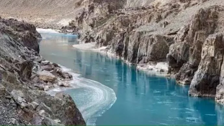
From its origin in the glaciers of Western Tibet, in the Tibet Autonomous Region (TAR), the first 2,840 km of the river is called Yarlung by China as it flows through Tibet. When it crosses the Sino-Indian LAC and snakes into Arunachal Pradesh of India, which China claims as South Tibet, it is called the Dihang. From Arunachal Pradesh throughout India, the river runs an additional 1,856 km. Upon reaching Assam, the river is known as Brahmputra.
Concerns relating to Brahmaputra grew bigger in the past few decades between India and China, when the latter, in its five-year plans while articulating development goals, started proposing dams. Although China has never disclosed officially the exact number of dams that it intends to build, various media sources say that at least 40 dams are proposed to be built in the Tibetan portion of the Brahmaputra basin so far, out of which 20 will be built on the Yarlung Tsangpo itself, with an aim to generate 60,000 MW of power. According to reports, nine large dam projects will be built at the ‘Great Bend’, a few kilometres upstream of the India-China border.
However, in November 2020, China’s 14th Five Year plan for 2021-2025 made India go jittery when it announced the construction of a super hydropower dam in Medong near the Indian border on the Great Bend. The 50-meter high dam with a power generation capacity of 60 gigawatt is perceived to be the world’s largest dam in south-eastern Tibet on the foothills of the Himalayas where the river bends sharply and rushes through the 500-km Yarlung Tsangpo gorge. As per media reports, the dam is commissioned to the Power Construction Corporation of China (PowerChina), a Chinese state-owned enterprise (SOE).
The construction of mega dams carries the threat of dry spell in the winter season and flash flood during summer especially in the two north-eastern states of Assam and Arunachal Pradesh. The proposed dam site is just about 30 km from the Indian border. In addition to this, China has already commissioned the Zangmu dam in the middle reaches of the river and three other such dams are coming up at Dagu, Jiexu and Jiacha, all in the same geographical location.
Now dams in any rivers in the Great Bend are a cause of concern given the bend is right on top of three mountain regions and in a seismic zone. It has been the epicentre of some of the most severe earthquakes recorded in history over the century including the devastating 1950 earthquake that changed the course of Brahmaputra in Assam.
Talking to Outlook, Dr. Partha Jyoti Das, an Interdisciplinary Researcher in Environment, Society and Development, said, "Any damage to the mega dam, if constructed here, will cause dam breaching and consequent flood havoc in India and Bangladesh. We have seen several incidents of natural damming of the Tsangpo and its tributaries following large-scale landslides leading to catastrophic to moderate flash flooding both in Tibet and downstream India (mainly in Arunachal Pradesh and Assam in the last three decades.)"
The Yigong (a tributary of the Tsangpo) flash floods that occurred in the month of June in the year 2000 devastated many areas in the East Siang district of Arunachal Pradesh and the Dhemaji district of Assam, and remains a classic example of catastrophic hydroclimatic disasters triggered in upstream Tibet region but suffered most in the downstream Indian region. Other similar incidents, but of lesser magnitude, happened in the years 2017, 2018 and 2021, causing degradation of water quality and flooding in downstream Siang and the Brahmaputra. Such risks are on the increase given the susceptibility of the Himalayan region to climate change and its diverse impacts, adds Dr. Das.
A Trust Deficit
China has been maintaining that most of the dams that it is building or planning to build in future in the upper reaches of Yarlung are run off the river - which means they do not involve any diversion or blocking of water. However, this claim was contested by Indian experts when on numerous occasions the Brahmaputra in the lower reaches of Arunachal Pradesh went dry during the winters and turbid at other times.
In 2000, 30 people were killed and nearly 100 went missing in Arunachal Pradesh due to flash floods following breach of a dam on the Yarlung Tsangpo. In 2012, Siang, the largest tributary of Brahmaputra, had run completely dry in Pasighat of Arunachal Pradesh. This again happened in 2018.
On many occasions, the water of the Siang, a lifeline for the people of Arunachal Pradesh became turbid thereby unfit for human use and also led to massive death of aquatic lives and cattle. In 2020, Pasighat West MLA Ninong Ering had raised the issue in the Indian Parliament where he had expressed apprehension that China had a role behind the Siang’s turbidity. He appealed to the Indian government to take up the issue with its Chinese counterpart.
The border dispute and low levels of trust between the two countries (as well as between India and Bangladesh) has long prevented a water-sharing treaty or a more formalised water management system. However, after the 2000 incident, India had contended that it could have been prevented had China been more transparent about the upstream river conditions, a claim that China does not agree with. Two years later, China agreed to share hydrological data with India during the flood season between May and October. China and India also agreed to establish a working group that meets annually to discuss river issues.
But the withdrawal of hydrological data by China during the Doklam standoff in 2020 made many believe that China was deliberately trying to show its power over the river as the upper riparian state.
During the stand-off that began in May 2020, as the Chinese and Indian forces engaged in an intensive face off in Galwan, India did not receive hydrological data from China. The latter offered a technical explanation that the monitoring stations were being renovated during that period.
“China’s politicisation of the data could set a worrisome precedent in its evolving use of coercive “sticks” in regional disputes and should be opposed within and beyond the region. The data cutoff came at a time when Sino-India cooperation along the Brahmaputra was already precarious,” writes, Dr. Joel Wothnow, a Senior Research Fellow at the National Defense University.
According to Wothnow, the border dispute and low levels of trust between the two countries (as well as between India and Bangladesh) has long prevented a water-sharing treaty or a more formalized water management system of the sort that exists in the Nile, Mekong, or Danube basins.
The already strained relationship between India and China, especially post the 1962 Sino-India war has been further soured by suspicion of both countries about the way the river Brahmaputra has been used by the other. While India sees any activity upon the Brahmaputra by China near the Indo-China border as a threat to border security, India's activities in the Arunachal Pradesh are perceived as an effort to make its foothold strong in a territory that China claims to be a part of Tibet.