Cyclone Michaung has finally made landfall near Bapatla in Andhra Pradesh on Tuesday as a severe cyclonic storm with a maximum sustained wind speed of 90-100 kmph gusting to 110 kmph, as forecastd by the India Meteorological Department (IMD)
Earlier on Monday, IMD issued a warning as the deep depression over the Bay of Bengal transformed into a severe cyclonic storm named ‘Michaung’ (pronounced as MIGJAUM).
Initially anticipated to make landfall over Tamil Nadu’s Chennai by Monday (December 4), the cyclone has altered its course. Currently positioned over the Bay of Bengal, the cyclone has made landfall off the Andhra Pradesh coast in the afternoon of December 5. This is the first cyclone to cross the Andhra Pradesh coast after cyclone Gulab which developed in September 2021.
Cyclone Michaung has already unleashed heavy rains and strong winds in Tamil Nadu and Puducherry. The coastal areas of Tamil Nadu witnessed uprooted trees and fallen electricity poles due to the impact of the cyclone.
A cyclone, by definition, is a storm or system of winds that rotates about a centre of low atmospheric pressure, advancing at a speed of 20 to 30 miles (30 to 50 kilometres) an hour, often accompanied by significant rainfall.
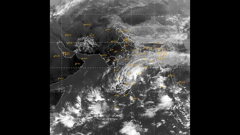
Path and Track:
According to India Meteorological Department's (IMD) bulletin issued this morning, the cyclone over west central Bay of Bengal and off south Andhra Pradesh coast has moved northwards with a speed of 12 kmph in the morning of 5th December, 2023 over the same region about 40 km northeast of kavali, 80 km north-northeast of nellore(43245), 80 km south-southwest of bapatla(43220) and 140 km south-southwest of machilipatnam.


The storm was previously expected to intensify gradually as it moves nearly northwards, almost parallel and close to the south Andhra Pradesh coast. The landfall is projected to occur between Nellore and Machilipatnam, close to Bapatla, during the forenoon of Tuesday, December 5. At that time, it is forecasted to be a Severe Cyclonic Storm with a maximum sustained wind speed of 90-100 kmph, gusting to 110 kmph.


Rainfall Warning:
The Indian Meteorological Department (IMD) also issued a detailed rainfall warning across several regions. South Coastal Andhra Pradesh is anticipated to experience widespread light to moderate rains, coupled with isolated heavy to very heavy showers from Sunday to next Wednesday (Dec 3-6). The threat intensifies on Monday and Tuesday (Dec 4-5) with the possibility of extremely heavy falls, prompting a red warning for the entire coastal region during this 48-hour period. Residents are advised to 'take action' to ensure their safety.
In Andhra’s Rayalaseema region, similar conditions are expected, with widespread light to moderate rains and isolated heavy showers from Saturday to Monday (Dec 2-4), including the likelihood of very heavy rainfall on Sunday (Dec 3).
The influence of Cyclone Michaung extends beyond Andhra Pradesh, with anticipated heavy precipitation affecting the neighbouring states of Tamil Nadu from December 2 to 4 and Odisha from December 4 to 6.
Additionally, the cyclone's presence is expected to create adverse conditions, including rough seas in the Bay of Bengal and stormy winds along the eastern coast. In response to these potential dangers, fisherfolk are strongly advised to refrain from venturing into the waters until authorities declare the situation to be under control.