Just earlier on Thursday, Hurricane Lee was categorized as a less powerful Category 1 storm. However, it has exhibited exceptional speed in intensification over the warm waters of the Atlantic Ocean, doubling its wind speeds within the past 24 hours.
As of the 11 p.m. advisory, Hurricane Lee is situated approximately 700 miles east of the northern Leeward Islands.
Projections indicate that the storm is likely to reach its peak intensity by the upcoming weekend. It is expected to remain a dangerous hurricane as it progresses over the southwestern Atlantic early next week. However, it is too early to determine whether Hurricane Lee will directly impact the mainland of the United States.
The National Hurricane Center has issued warnings about the potential dangers associated with Hurricane Lee. Dangerous surf and rip currents are predicted to affect the northern Caribbean starting on Friday, and these effects will gradually extend to the United States by Sunday.
It is increasingly likely that the center of Hurricane Lee will pass north of the Leeward Islands, the Virgin Islands, and Puerto Rico over the weekend and into the early part of the following week.
Additionally, on Thursday, a tropical depression in the eastern Atlantic strengthened into Tropical Storm Margot, situated a few hundred miles west of the Cabo Verde Islands. The current forecast track for Tropical Storm Margot indicates a northward turn over the central Atlantic early next week. However, there are no imminent threats to land areas reported as of Thursday.
The movement of Hurricane Lee is contingent on various factors, notably the Bermuda High, an area of high pressure over the Atlantic. The weakening of this high-pressure system next week will influence Hurricane Lee's northward trajectory.
Crucially, the position of the jet stream, characterized by strong upper-level winds capable of altering a hurricane's path, will play a decisive role in guiding Lee's movement. Various scenarios are plausible, including a quick northward turn if high pressure weakens significantly or a more offshore path along the East Coast if the jet stream acts as a barrier.
However, it's important to note that these factors are still evolving, and Hurricane Lee is at least seven days away from posing a potential threat to the East Coast. Continued monitoring and preparedness are advised as the situation develops.
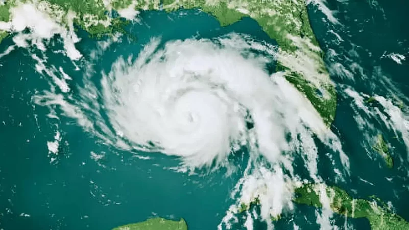
Hurricane Lee becomes Category 5 storm as it approaches the Caribbean
Updated on:
Published at:
In a recent update from the National Hurricane Center, Hurricane Lee has rapidly intensified into a Category 5 storm, with maximum sustained winds of 160 mph. The hurricane is currently located over the Atlantic Ocean, well to the east of the Caribbean, as reported in the 11 p.m. ET advisory on Thursday
Updated on:
Published at:
Hurricane
Click/Scan to Subscribe

- Previous Story
 Trump-Zelenskyy Meet: Ukraine-Russia Peace Deal 'Closer Than Ever'
 - Next StoryUS Strike on Suspected Drug-Smuggling Boat Kills Three, Death Toll Reaches 205


RELATED STORIES
More From the author


Watch


Photos


×