The Indian Space Research Organisation (ISRO) successfully launched the NVS-1 satellite on Monday.
The NVS-1 is the second-generation navigation satellite that's part of India's regional navigation systems. It has both civilian and strategic uses.
The ISRO has already launched nine first-generation navigation satellites, one of which could not be placed as the launch vehicle crashed into the sea.
The second-generation of satellites are called Navigation Indian Constellation (NavIC). They are the successors to first-generation constellation called Indian Regional Navigation Satellite System (IRNSS). The NavIC will have increased lifespan, technical capabilities, and applications.
Here we explain what's NVS-1, how did the launch go, and what's NavIC and what are its uses.
ISRO's successful launch of NVS-1
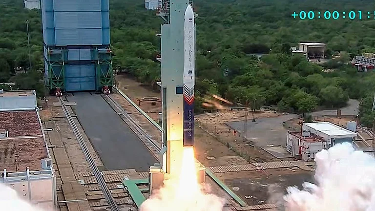
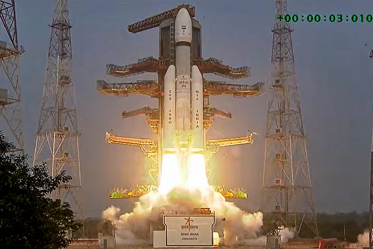
The ISRO successfully launched the NVS-1 satellite on Monday from the GSLV rocket.
The lauch took place at Satish Dhawan Space Centre-Sriharikota Range (SDPC-SHAR) at Sriharikota, Andhra Pradesh.
The GSLV rocket placed the NVS-1 in Geosynchronous Transfer Orbit. Subsequent orbit-raising manoeuvres will take NVS-01 navigation satellite into the intended geosynchronous orbit, according to ISRO.
At the end of a 27.5 hour countdown, the 51.7 metre tall, 3-stage Geosynchronous Satellite Launch Vehicle with a cryogenic upper stage, lifted off at a prefixed time of 10.42 am from the second launch pad at the spaceport. This was GSLV's 15th flight.


The Monday's success came after the GSLV F10 "debacle", said ISRO Chairman S Somanath, referring to the anomaly in the cryogenic stage of the launch vehicle in August 2021, following which the then mission could not be fufilled.
Somanath expressed joy that "corrections in cryogenic stage and lessons learnt have really paid benefits" and credited the Failure Analysis Committee for addressing the problem.
Somanath further said NVS-01 is a second generation satellite with additional capabilities. He also said that the signals will be more secure and a civilian frequency band has been introduced.
What is the NVS-1 satellite?
The NVS-1 satellite is the second-generation navigation satellite launched by ISRO.
The NVS-1 is the first of seven such satellites to be launched. Together, these satellites would form the regional navigation system of India, which can be understood as 'Indian GPS' in simple terms.
These satellites are part of the Navigation Indian Constellation (NavIC). They are the successors to first-generation constellation called Indian Regional Navigation Satellite System (IRNSS). The NavIC will have increased lifespan, technical capabilities, and applications.
Under the previous IRNSS programme, ISRO has already launched similar navigation satellites named IRNSS-1A, IRNSS-1B, IRNSS-1C, IRNSS-1D, IRNSS-1E, IRNSS-1F, IRNSS-1G, IRNSS-1H, and IRNSS-1I. Of these missions, IRNSS-1H was not successful as the satellite could not be placed into orbit. It was replaced by IRNSS-1I which was successfully launched on April 12, 2018.
For the first time, the NVS-1 has also carried a Made in India rubidium atomic clock. Earlier, the scientists opted for imported ones. The Ahmedabad-based Space Applications Centre developed the clock, which ISRO said was significant as only a handful of countries possessed this important technology.
What is NavIC, what are its uses?
The NVS-1 is the first satellite to be launched as part of the second-generation constellation called Navigation Indian Constellation (NavIC).
The first-generation constellation of such navigation satellites that were sent into space before NVS-1 were known as Indian Regional Navigation Satellite System (IRNSS).
The NavIC is envisioned as a regional navigation system which would give India accurate and real-time satellite imagery and geospatial information. It will cover the entirety of India and a radius of 1,500 kms from Indian borders, covering most of the immediate Indian neighbourhood in South Asia.
Since the NavIC covers the Indian neighbourhood as well, it has strategic and military uses as well besides more obvious civilian uses.
"NavIC is designed with a constellation of 7 satellitesand a network of ground stations operating 24x7...The ground network consists of control centre, precise timing facility, range and integrity monitoring stations, two-way ranging stations, etc. NavIC offers two services: Standard Position Service (SPS) for civilian users and Restricted Service (RS) for strategic users," says ISRO on its website.
The ISRO also says that NavIC signals are designed to provide user position accuracy better than 20 metres and timing accuracy better than 50 nanoseconds.
The ISRO lists the following applications of the NavIC on its website:
- Transportation (terrestrial, aerial and marine)
- Location-based services
- Personal mobility
- Resource monitoring
- Surveying and geodesy
- Scientific research
- Time dissemination and synchronisation
- Safety-of-life alert dissemination
Advantages of NVS-1 and NavIC
The NVS-1 satellite and NavIC system have several advantages, ranging from increased lifespan to more applications.
Once complete, the NavIC would place India in the elite group of countries with their own global positioning systems.
"Once fully operational, NavIC open-signals will be accurate up to 5 metres and restricted signals will be even more accurate. GPS signals by contrast are accurate up to 20 metres. Work is underway to set up ground stations in Japan, France, and Russia, ISRO officials said," reported The Indian Express.
The Express also reported that only four global positioning systems exist and India's would be the only regional navigation system.
"India would be the only country that has a regional satellite-based navigation system. There are four global satellite-based navigation systems — the American GPS, the Russian GLONASS (GLObalnaya NAvigatsionnaya Sputnikovaya Sistema), the European Galileo, and the Chinese Beidou," reported The Express.
Moreover, it is for the first time that NVS-1 would send signals that can be used by wearable devices like smartwatches and smartphones. Qualcomm has already partnered with ISRO to include NavIC in its new processors for smartphones, according to a report in Hindustan Times.
However, the American GPS still remains the standard on wearable devices and ISRO has a long road ahead in this segment but it is great start nonetheless.
The NavIC has a range of other civilian and strategic purposes as well.
The Express reports, "The receivers have now been developed, and the NavIC is in use for projects like public vehicle safety, power grid synchronisation, real-time train information systems, and fishermen's safety."
Strategically, the satellite system gives India independence in terms of monitoring its neighbourhood for security and operational purposes.
Notably, the Air Force chief VR Chaudhari and several Air Force and Indian Army officers were present at the ISRO mission control centre at the time of the launch of NVS-1.
(With PTI inputs)