Super typhoons are Pacific tropical cyclones with sustained winds exceeding 150 mph.
They develop from tropical disturbances over warm ocean waters with low wind shear.
Super typhoons cause extreme winds, storm surge flooding, torrential rain, and massive infrastructure damage.
They differ from hurricanes only in terms of location and regional naming conventions.
Early forecasts, evacuations, resilient building codes, and community preparedness can reduce the impacts of typhoons.
Super typhoons rank among the most powerful and destructive tropical cyclones on Earth. Forming over the warm waters of the western North Pacific Ocean, these storms pack sustained winds exceeding 150 mph and bring devastating impacts to coastal and inland communities. Understanding their formation, causes, effects, and preparedness measures can save lives and minimize damage.
What Is a Super Typhoon?
A super typhoon is the highest intensity category of tropical cyclone recognized by meteorological agencies in the western North Pacific basin. The Japan Meteorological Agency (JMA) defines a typhoon when sustained winds reach at least 74 mph, while the U.S. Joint Typhoon Warning Center (JTWC) designates a “super typhoon” once maximum sustained winds exceed 150 mph for one minute. These storms often feature exceptionally low central pressure, rapid intensification, and expansive wind fields.
How Do Super Typhoons Form?
Super typhoons originate from tropical disturbances—clusters of thunderstorms over warm ocean waters—typically between May and November. Key developmental stages include:
Tropical disturbance: Organized thunderstorm activity with minimal rotation.
Tropical depression: Defined as a low-pressure center with wind speeds up to 38 mph.
Tropical storm: Sustained winds between 39 mph and 73 mph; named by agencies.
Typhoon: Winds exceed 74 mph; structure consolidates around a clear eye.
Super typhoon: Sustained winds exceed 150 mph; extremely low central pressure.


Main Causes of Super Typhoons
Several environmental factors drive the formation and intensification of super typhoons:
Sea surface temperature: Waters above 26.5 °C provide the heat and moisture that fuel storm development and intensification.
Atmospheric instability: A humid, unstable atmosphere promotes rising air currents and thunderstorm activity.
Low vertical wind shear: Minimal change in wind speed and direction with altitude allows the storm structure to remain coherent and strengthen.
Coriolis effect: The Earth’s rotation induces the cyclonic spin necessary for storm circulation, typically initiating development at least 5° latitude from the equator.
Moist mid-troposphere: A humid environment in the mid-levels of the atmosphere sustains deep convection, supporting rapid intensification.
Super Typhoon vs Hurricane: What’s the Difference?
Super typhoons and hurricanes are essentially the same weather phenomenon, tropical cyclones, but they are distinguished by where they form and how they are classified. Super typhoons develop in the western North Pacific, whereas hurricanes arise in the Atlantic and eastern North Pacific. In terms of intensity, the U.S. Joint Typhoon Warning Center designates storms with sustained winds above 150 mph as super typhoons, a range that corresponds to Category 4 and 5 hurricanes on the Saffir–Simpson scale (storms with winds above 130 mph). Their peak seasons overlap but differ slightly: super typhoons most often occur from July through October, while hurricane activity typically peaks between August and September. Finally, although both types of storms receive names, each basin follows its own predetermined naming lists and conventions.
Devastating Impacts of Super Typhoons
Super typhoons unleash multiple hazards:
Extreme winds: Destructive gusts topple trees, power lines, and weak structures; winds above 150 mph can demolish well-built homes.
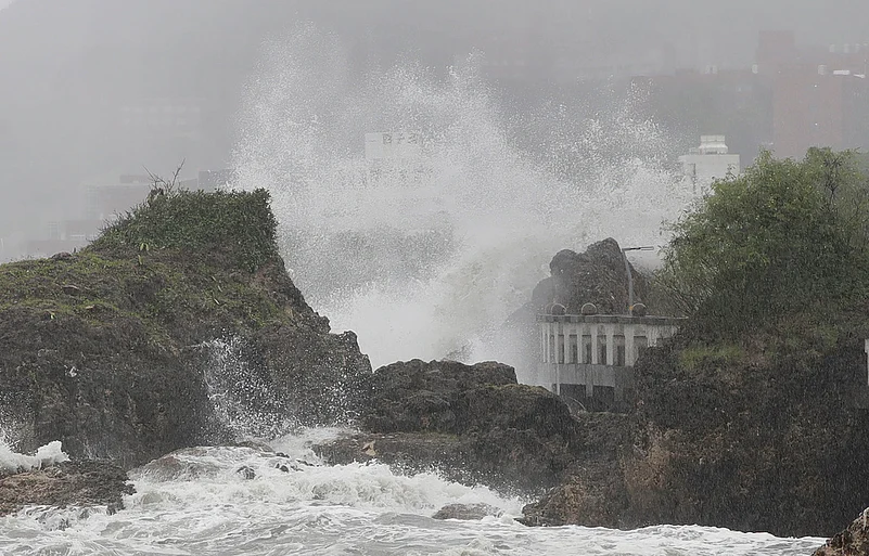
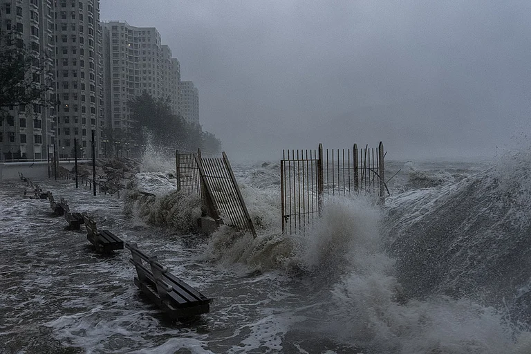
Storm surge: Rising ocean waters driven by wind and low pressure can inundate coastal areas, causing severe flooding and erosion.
Heavy rainfall and flooding: Torrential rains lead to inland and flash flooding, landslides, and river overflows, endangering downstream communities.
Economic losses: Damage to infrastructure, agriculture, fisheries, and housing often amounts to billions in insured and uninsured losses.
Casualties and displacement: High winds, flooding, and debris threaten lives and force mass evacuations, with recovery hampered by damaged roads and utilities.

Early Warning Systems and Disaster Preparedness
Effective early warning and preparedness strategies can significantly reduce super typhoon impacts:
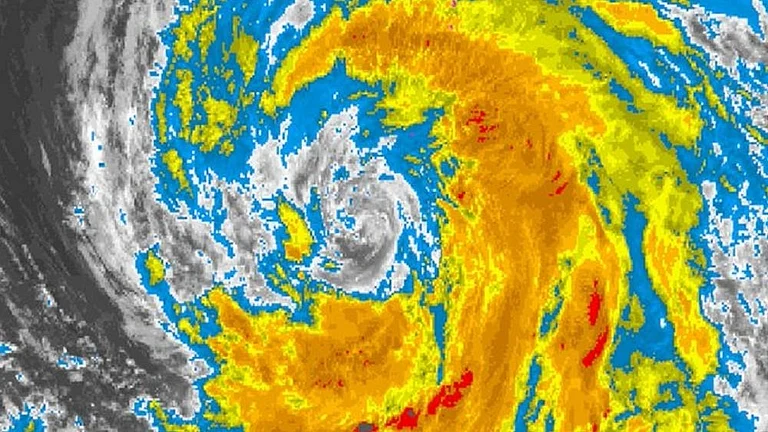
Advanced forecasting: Satellite imagery, ocean buoys, and computer models provide days of lead time for storm track and intensity predictions.
Alert dissemination: Governments and meteorological agencies use SMS alerts, media broadcasts, and community networks to inform at-risk populations.
Evacuation planning: Designated shelters, clear evacuation routes, and pre-positioned relief supplies ensure orderly movement and basic needs fulfillment.
Resilient infrastructure: Building codes in typhoon-prone regions mandate wind-resistant designs, elevated structures, and flood barriers.
Community education: Public awareness campaigns teach individuals to prepare emergency kits, secure property, and heed official warnings.
Super typhoons remain a formidable threat to millions of people across Asia’s coastal regions. Continued investment in forecasting technology, resilient infrastructure, and community preparedness is essential to mitigate their devastating impacts and safeguard vulnerable populations.