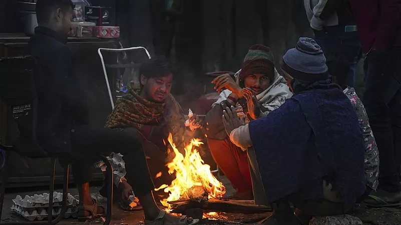
Large parts of Delhi shivered under a "severe" cold day on Monday, with the maximum temperature dropping 10 notches below normal at some places. Meteorologists attributed the sharp drop in day temperatures to frigid northwesterly winds barrelling through the plains and reduced sunshine due to foggy weather.
According to the weather office, a cold day is when the minimum temperature is less than or equal to 10 degrees Celsius and the maximum temperature is at least 4.5 degrees Celsius below normal. A severe cold day is when the maximum is below normal by 6.5 notches or more. In the morning, dense fog lowered visibility to 50 metres in some areas of the city, affecting road and rail traffic. Ten trains were reported running late by an hour and 45 minutes to three-and-a-half hours, a railway spokesperson said.
The Safdarjung observatory, Delhi's primary weather station, logged a minimum temperature of five degrees Celsius -- three notches below normal. The maximum temperature settled at 15.6 degrees Celsius, six notches below normal and the lowest day temperature in December since December 18, 2020 (15.2 degrees Celsius), according to the weather office. The Palam observatory recorded a minimum temperature of 6.5 degrees Celsius and a maximum of 12.5 degrees Celsius, a departure of nine degrees Celsius from normal.
Jafarpur in southwest Delhi logged a minimum temperature of 4.2 degrees Celsius and a maximum of 11 degrees Celsius, 10 notches below normal. Mungeshpur in northwest Delhi recorded a minimum temperature of 5.3 degrees Celsius and a maximum of 11.4 degrees Celsius against the season's normal maximum temperature of 21.4 degrees Celsius.


The automatic weather stations at Ayanagar, Lodhi Road, Ridge, Najafgarh, Pitampura and Mayur Vihar recorded the maximum temperature six to eight notches below normal. Mahesh Palawat, vice president (meteorology and climate change), Skymet Weather, said a western disturbance led to a fresh spell of snowfall in the mountains on December 25-26 and cold northwesterly winds are now sweeping through the plains after its retreat.
"An increase in the humidity levels due to the WD resulted in dense to very dense fog which reduced the sunshine, pulling down the day temperature further," he said. Palawat said the wind chill factor -- a measure of the rate of heat loss from skin that is exposed to the air -- is also high. The higher the wind speed during cold weather, the colder it feels on the skin if a person is outside.
Delhi clocked a top wind speed of 15 kilometres per hour on Monday. Dense to very dense fog prevailed in some parts of the National Capital Region (NCR), Haryana, Punjab, west Uttar Pradesh and north Rajasthan on Monday. Bathinda in Punjab and Bikaner in Rajasthan reported zero visibility, while it dropped to 50 metres and below at Ambala, Hisar, Amritsar, Patiala, Ganganagar, Churu and Bareilly.
Foggy conditions will persist in these areas over the next few days, the India Meteorological Department (IMD) said. According to the IMD, "very dense" fog is when visibility is between 0 and 50 metres, 51 and 200 metres is "dense", 201 and 500 "moderate", and 501 and 1,000 "shallow". In the plains, the IMD declares a cold wave if the minimum temperature dips to four degrees Celsius or when the minimum temperature is 10 degrees Celsius or below and is 4.5 notches below normal.
A "severe" cold wave is when the minimum temperature dips to two degrees Celsius or the departure from normal is more than 6.4 degrees Celsius.