When one thinks of slavery, one usually thinks of Africans transported in ships to Europe and the Americas in the medieval era. The historical Transatlantic slave trade remains the most stark popular memory of human trafficking and its associated evils.
Slavery, however, has neither been unique to the West nor it is a thing of past. Bonded labour and debt bondage are just two forms of slavery in the modern world. Human trafficking is key to enabling slavery today — as it was centuries ago. The difference is that now it's not legal and governments and non-governmental organisations (NGOs) are on active pursuit of traffickers.
Rather than moving one person from one place to another, it's the exploitation that's central to understanding the modern-day human trafficking.
"Human trafficking can include, but does not require, movement. People may be considered trafficking victims regardless of whether they were born into a state of servitude, were exploited in their home town, were transported to the exploitative situation, previously consented to work for a trafficker, or participated in a crime as a direct result of being trafficked. At the heart of this phenomenon is the traffickers’ aim to exploit and enslave their victims and the myriad coercive and deceptive practices they use to do so," says the US Department of State.
Just like traffickers have adapted to the modern time by deploying fast boats or using tunnels, those tackling it have also adapted. Satellite imagery has thus emerged as a tool to tackle human trafficking. It's used to track boats trafficking persons and find and monitor sites for housing trafficked or enslaved persons.
Human trafficking and satellite imagery
Non-governmental organisations (NGOs) and academics have used satellite imagery in recent years in multiple ways to tackle human trafficking and forced labour:
1. To track compounds where trafficked persons are housed
2. To track vessels used to transport trafficked persons
3. To map and have an accurate assessment of establishments more likely to have trafficked persons, such as brick kilns in India
For decades, satellite imagery was strictly for government and was largely devoted to security or weather purposes. With the rise of commercial satellite imagery services, however, things have changed. Maxar and Planet are two leading companies offering these services.
"High-resolution satellite imagery can assist NGO and IGO groundwork as a tool for assessing population number changes and detailed mapping for access and resource management purposes. Satellite images can also be coordinated with any on the ground staff requiring access to current data, particularly in changing hostile conditions. Used as evidence in the International Court of Justice, satellite imagery may assist prosecute human rights violations," says commercial satellite industry-centric news website Via Satellites.
A major focus of satellite imagery in this domain is to track compounds associated with trafficking, but Space.com reports there are other applications too.
"Aside from examining compounds from orbit, human trafficking can also be detected by other satellite means. Data from satellites operated by the San Francisco-based company Planet, for example, is used by Stanford University's Human Trafficking Data Lab to seek out 'forced labor' in deforested areas of Brazil's Amazon rainforest," says Space.com.
The uses of satellite data are expanding, particularly through crowd sourced analysis and as a result of increased awareness of human rights organisations, says Owen Hawkins, Operations Director at Earth-i, which collaborated with the University of Nottingham on their "Slavery from Space" project.
Hawkins told Via Satellites, "We can learn from satellite images and videos the locations and operations of illegal fishing boats, farms and brick kilns, all locations where the employment of slaves and child slaves is more likely. These uses of satellite data are expanding, particularly through crowd sourced analysis and as a result of increased awareness of human rights organisations."
Case studies: Tracking trafficking via satellites in Southeast Asia, Africa
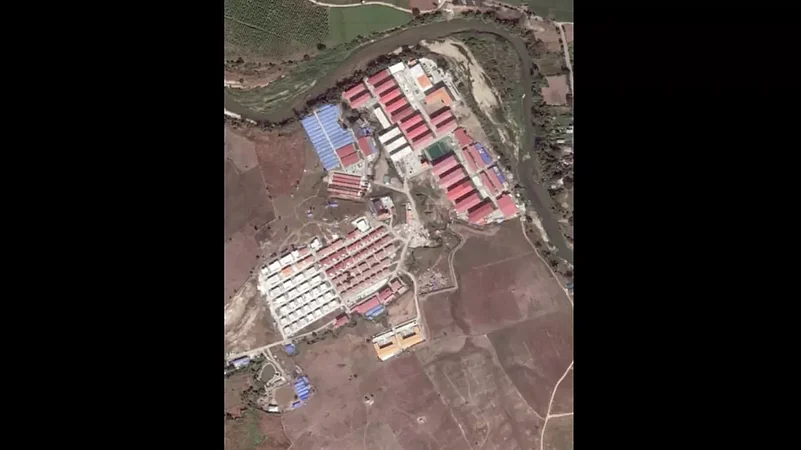
In June, the International Justice Mission (IJM) shared on Twitter that they tracked human trafficking compounds in Myanmar for three years.
"These satellite images reveal scamming compounds located in Myanmar where individuals are being tortured and forced to scam people online. These images show the same area in Myanmar over the last three years...Forced scamming is an emerging form of slavery and trafficking that is spreading fast," says the IJM in a video featuring the satellite imagery that helped it find trafficking sites in Myanmar.
The IJM's report was based on satellite image from Maxar. The partnership also resulted in the rescue of dozens of children in Africa.
In its 2020-21, IJM partnered with Ghana's government and Maxar to use its imagery services. A total of 71 children were rescued.
"Using their [Maxar's] Secure Watch satellite imagery platform, the team mapped remote regions of Lake Volta and pinpointed locations. So far, this has resulted in the rescue of more than 71 children from enslavement. This has been a pivotal partnership, especially during the pandemic, as the team has been forced to work creatively to fight slavery, and we look forward to all we can do together moving forward," said the IJM in its 2020-21 report.


