On the evening of August 15, 1950, the day India was celebrating its third Independence Day, Sarbananda Mazindar, 14, a resident of a small village named Kacharihat in the Golaghat district of Assam, was studying at his home. Suddenly, everything started shaking and Mazindar, along with his parents, rushed out of the house.
“The ground was shaking, and we heard roaring sounds. I got very scared. Later, we came to know that portions of tree-laden hillsides of Arunachal had crashed into the valley of Assam. The tremors stopped, but the horrifying sounds continued until midnight,” Mazindar, now 89, tells Outlook. He is now a retired school principal.
The 8.6 magnitude earthquake had its epicentre in Rima, a region in Tibet. It caused massive devastation throughout the eastern part of Assam and its frontier regions—the Mishmi Hills and Abor Hills—which fall in present-day Arunachal Pradesh.
“The Brahmaputra River started flowing backwards. People saw huge timber logs floating in the river that had fallen in Arunachal. Some animals like deer and buffaloes also became the unfortunate victims of the earthquake,” adds Mazindar.
The United States Geological Survey estimates that nearly 1,530 people lost their lives and around 2,000 homes perished in the 1950 earthquake. However, locals believe that the actual number of deaths stands at 4,000-plus.

According to a news report published after the quake, Bishnuram Medhi, the then-Assam chief minister had told his legislators, “The exact number of casualties would perhaps never be known as no traces of many villages had been left in the Subansiri Valley of the North Lakhimpur sub-division as well as the Abor and Mishmi Hills of the North East Frontier Agency.”
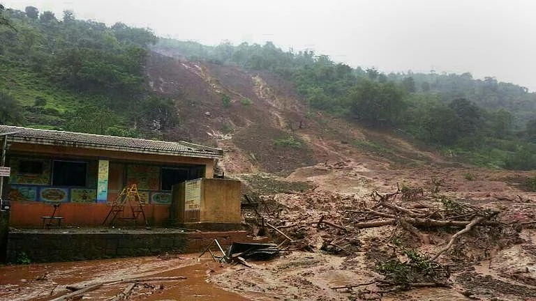
Apart from altering the geography of the region, the 1950 earthquake led to a change in the river system. In his account, ‘The Great Assam Earthquake 1950’, F Kingdon-Ward, a botanist who was travelling to the upper reaches of the region when tragedy struck, stated that the earthquake resulted in multiple landslides in the hills and the rivers got flooded with enormous amounts of sediments, which led to a change in the river pattern.
“The 1950 earthquake severely mutilated the river’s capacity as a natural carrier. Restoration of the pre-earthquake situation is not visualised either by the state or by the populace”, writes Dr Arupjyoti Saikia in his book, ‘The Unquiet River- A Biography of the Brahmaputra’.
“The earthquakes of 1897 and 1950 forced the Brahmaputra and its floodplains to undergo several major short-term and long-term transformations. These included the shifting of the river courses and the rise of the bed during the earthquake and then sedimentation from the landslides. The 1897 earthquake did not just alter the course of the river, but beds of rivers, tanks, or even wells were ridged up or filled with outpouring sand from fissures, thereby, generally disturbing the drainage system of the land and causing extensive flooding,” the book states.
The years following the 1950 earthquake saw massive floods of greater intensity than usual. While new areas started getting flooded, some of the flood-prone areas started drying up.
According to Dr Dhrubajyoti Saharia, a professor at the Department of Geography at Guwahati University, the 1950 earthquake is one of the many factors why Assam gets flooded year after year, but this is not the only cause of incessant floods.
“Assam has had a history of floods. However, anthropogenic factors have contributed more to the recent floods. Activities in the catchment areas, deforestation and slope destabilisation are major reasons for flooding. The Arunachal-Himalaya region is loose and sedimentary and even light rains can cause the sediments to flow downstream.”
Soil erosion, especially after the 1950 earthquake, has become a perennial problem, which renders thousands homeless every year. Liquefaction during the earthquake caused cracks in the soil resulting in reduced soil resistance and thus leading to erosion by the rivers in coming years.
“Earthquake-induced changes in the flooding pattern forced peasants to move out to safer areas in search of cultivable lands and places of residence. This happened during both, the 1897 and, 1950 earthquakes,” writes Saikia.
According to the Water Resource Department of Assam, every year, damages caused by erosion by rivers like the Brahmaputra, Barak and its tributaries run into several hundred crores. Erosion of banks is another serious issue that the state has been facing for over six decades now. The Brahmaputra and its tributaries have eroded more than 4.27 lakh hectares of land since 1950, which is 7.40 per cent of the area of the state.
“As assessed, the annual average loss of land is nearly 8,000 hectares. The width of the Brahmaputra River has increased by up to 15 km at some places due to bank erosion. The surveys carried out at different periods reflect an alarming picture regarding the widening of the river,” as per the Water Resource Department.
The perennial flood and erosion problem in the state, especially in the lower reaches of the Brahmaputra Valley, has led to the problem of environmental migration. Thousands of people get displaced due to these factors, and they are forced to take shelter in forests and reserved lands. While some return to their homes after the flood water subsides, the victims of erosion have no option but to find new places to live. These people often face forced evictions when authorities announce the freeing up of government lands from “encroachment”. The Assam government, especially after the BJP came to power in 2016, has been conducting eviction drives in these places leading to the rise of a migratory community of Internally Displaced People (IDPs), a majority of who are Bengali Muslims from char areas (sand bars).
Talking to Outlook, Dr Nazimuddin Siddique, Assistant Professor at the Department of Sociology at Nagaland University, says, “The government has completely failed to solve the long-standing problems of erosion and flood. It has not devised a proper rehabilitation strategy. Because of this, thousands of people face internal displacement. Most people living in flood-prone zones are poor and marginalised Muslims. Owing to floods and unabated river bank erosion, these people become landless and migrate to different places, especially cities, for survival. These marginalised landless people often face discrimination.”