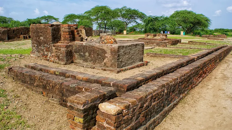
A Bronze Age civilisation in the northwestern regions of South Asia, the Indus Valley civilisation flourished in the basins of the Indus River. It extended from Pakistan’s Balochistan in the west to India’s western Uttar Pradesh in the east, and from northeastern Afghanistan in the north to Gujarat in the south.
Also known as the Harappan Civilisation, after its type site, Harappa, the first site to be excavated in the early-20th century in Punjab province of British India (now in Pakistan), it was renowned for its urban planning, standardised weights and measures, seal carving, and metallurgy. As many as 1,400 Indus Valley Civilisation sites have been discovered, of which 925 sites are in India and 475 in Pakistan. Gujarat has more than 200 of these sites dotted largely at three destinations: Lothal, Surkotada, and Dholavira.

Rangpur in Limdi Taluka of Ahmedabad district was the first site to be re-exacavated after independence as it was suspected to be a Harappan outpost. It is believed that the Harappans probably started moving into Kutch around 2500 BCE, and decided to settle down there. Till now, 60 Indus settlements have been found in Kutch, of which 40 belong to the ‘early’ phase while the others exemplify mature Harappan culture. The many discoveries reveal that the Harappans brought their culture and way of life to Gujarat before the civilisation declined, causing large-scale migration from Kutch to the hinterland of Gujarat and even Saurashtra.
If you are a lover of history and ancient civilisations the Indus Valley trail is perfect for your next driving holiday. Begin your journey from Ahmedabad and trail the following route:
Lothal, Dholka
Time and Distance from Ahmedabad to Lothal: 78kms/1hr45min

The word Lothal, which means ‘Mound of the dead’ in Gujarati, is said to have been formed by combining the words Loth and thal (sthal). This single culture site, which showcases the Harappan culture in all its variant forms, was discovered in 1954. The most accessible Harappan-era
site in Western India, it was located along the Bhogava River, a tribute of the Sabarmati, and was essentially a port city. Said to be 3,700 years old, the site encompasses seven hectares and is 18 times smaller than Mohenjodaro. Lothal’s thick peripheral walls seem to have been designed to withstand repeated tidal floods. The Harappans were attracted to the town by its sheltered harbour and fertile hinterland. The quadrangular fortified layout is divided into two primary zones— the upper and the lower town. The citadel, or the upper town, is located in the south- eastern corner and can be demarcated by platforms of mud-brick that rise four metres in height. The citadel has wide streets, drains, and rows of bathing platforms, which suggests a high level of planning. A large structure, identified as a warehouse, and a square platform can also be seen. The lower town, which also enjoyed civic amenities, was subdivided into two sectors. The residential sector lay to the east and west of bazaar.
Surkotada, Rapar
Time and Distance from Lothal to Surkotada: 280kms/6hrs
The site at Surkotada was discovered in 1964. It is believed that a river flowed past the northeastern side in the days of yore, and emptied into the Little Rann. The Harappans came to Surkotada around 2300 BCE, and built a fortified citadel and residential annex, made of mud brick, mud lumps and rubble, and comprising houses with bath- rooms and drains. The site was occupied for 400 years with no breaks or desertions. Despite its small size, archaeologists consider Surkotada very important and place it at par with Kalibangan and Lothal, when it comes to planning. Many scholars feel that the location was strategic to control the eastward migration of the Harappans from Sind, which leads to the idea that Surkotada could have functioned as a regional capital or garrison town. Interesting finds include painted pottery (with Indus alphabets painted on them), copper objects, and a typical Harappa seal. A stash of copper beads and bangles, and terracotta toys, tanks, and beads have also been discovered. The Surkotada site is said to have turned up horse remains dating to 2000 BCE, which is considered a significant discovery.
For the next leg of your journey, halt at Bhuj for the night and then continue towards Dholavira.
Dholavira, Khadir Bet
Time and distance from Bhuj to Dholavira: 214kms/4.5 hours

Dholavira is said to be one of the five largest Indus Valley sites. The others include Mohenjodaro, Harappa, and Gharo Bhiro in Pakistan, and Rakhigarhi in India. Like other Indus Valley Civilisation sites, Dholavira—located in the Khadir island of Kutch—displays evidences of urban planning. Locally known as Kotada, the settlement has been divided by archaeologists into three sections: the citadel, middle town, and lower town. The Harappan city measures about 600m on the north-south axis and 775m on the east-west. An enormous fortification runs on all four sides of this settlement, and a series of reservoirs was found within them. The upper town, impressive and imposing, has a towering castle that stands cheek by jowl with double ram- parts. The embattled middle town has two or three gates in the enclosure to facilitate intercommunication with the lower town in the east and the open spaces on other sides. The lower town has a constructed area with several built-up projections and open recesses. There are numerous gateways, built-up areas, street systems, wells, and large open spaces within the fortification. Ten symbols can be seen on the northern gate of Dholavira, and have been dubbed the Dholavira Signboard. Chances are that this could be the oldest signboard in the entire world. The presence of a range of funerary structures found here also sheds light on the socio-religious beliefs of the people of the civilisation.


