A winter storm is expected to bring a mix of snow, rain, and strong winds to the Eastern United States this weekend. However, there is still some uncertainty regarding the storm's path, strength, and the amount of cold air that will be present along the coast.
Where is the storm now and where is it headed?
The disturbance responsible for triggering the storm's development in the Eastern region will move from the Southwest towards the Central Plains by Friday.
Here's a current radar snapshot depicting the areas in the Western region where this system is currently generating rain and snow. (with regular updates)

Snowfall amounts are expected to range from light to moderate in regions spanning from the southern Rockies to certain areas of Kansas, as well as the Texas and Oklahoma panhandles.
Peak impacts in the East will be over the Weekend
The most significant effects of this storm in the Eastern US are expected over the weekend. A low-pressure system will strengthen as it moves from the Deep South northward along the East Coast during this time. There's a possibility that the storm might evolve into a nor'easter, characterized by northeast-directed winds along portions of the Eastern Seaboard.


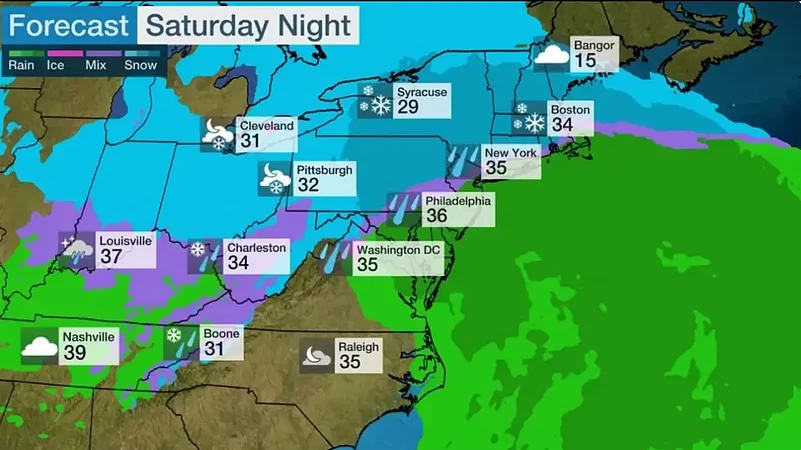
The path of the low-pressure system will enable the storm to generate either snowfall or a combination of rain and snow in regions where its moisture meets colder air to the north and west of the low's trajectory. This will occur from the Ohio Valley extending into portions of the Appalachians, mid-Atlantic, and Northeast on Saturday and Saturday night. Additionally, certain areas can anticipate gusty winds accompanying these conditions.
The storm will start to move away from the Northeast later on Sunday, but there will still be ongoing precipitation in the form of snow, rain, and windy conditions throughout the day.
You can observe the anticipated timing of the storm in the following three maps. The green shadings depict where rain is expected. Areas that are shaded blue are expected to see snow. Purple-shaded locations may see either rain or snow. Areas in pink are expected to see sleet or freezing rain (ice).


How much Snow and Ice to Expect
In recent days, the weather forecast has been marked by uncertainty due to various factors, including the storm's precise path, strength, and the availability of cold air.
Currently, the forecast indicates that cold air may not be widespread in certain coastal areas, leading to the possibility of a mix of rain and snow or even predominantly rain from Washington, D.C., to New York City. The most recent forecast suggests that the highest likelihood of significant snowfall (5 inches or more) will be to the north and west of the Interstate 95 corridor, covering central and northeast Pennsylvania, northern New Jersey, and parts of New York's Hudson Valley.
Additionally, parts of southern and central New England, including areas near Interstate 95, are also expected to have a heightened chance of significant snowfall (5 inches or more). This encompasses sections of the Boston, Providence, and Hartford metropolitan areas.
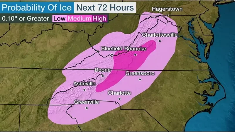
Furthermore, significant ice accumulations from freezing rain are anticipated in the southern Appalachians and adjacent regions of the Piedmont, stretching from western North Carolina into western Virginia.
Travel Advice from Weather Experts
The primary impact of this weekend's storm in the Eastern US will be adverse travel conditions. It is advisable to either avoid travel or consider delaying it, especially in regions where snow and ice are expected.
When was the last time it snowed in New York?
The last time that New York saw an inch of snow on a single calender day was February 13, 2022.