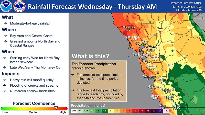
The San Francisco Bay Area, has been enjoying a good weather and abundant sunshine this week after floods and landslides. But it looks like residents will again have to brace themselves for a significant change as a powerful winter storm is set to impact the region on Wednesday and Thursday.
The National Weather Service predicts a substantial amount of rainfall, with San Francisco expecting three inches of rain. Meteorologist Kyla Grogan from KRON4 explained that a storm offshore is gearing up to bring substantial rain across the entire Bay Area and much-needed snow to the Sierra.
Tuesday will see dry skies as temperatures decrease and clouds start to gather. Grogan noted, "The rain will approach the North Bay late Tuesday night, and by rush hour on Wednesday morning, we will be in the thick of it. We could see some possible flooding in our urban areas. We are under a Flood Watch starting early Wednesday morning and lasting through Friday."
The main front of the atmospheric river is expected to cover the entire Bay Area on Wednesday. A Wind Advisory is also in effect during this time, with winds anticipated to be between 25-35 mph, and coastal areas could experience gusts up to 50 mph.
Despite the likelihood of heavy rainfall and slower movement at the onset, the weather service noted that this will be a transient system, gradually speeding up as it passes through the Bay Area.
The NWS also mentioned potential challenges such as rivers and creeks filling with heavy rainfall, a 15-30 percent chance of reaching flood stage in the North Bay, and the likelihood of roadway flooding and shallow landslides. Additionally, ridge tops and extremely exposed coastal areas could experience isolated wind gusts between 50-60 mph.