The Himalayas have witnessed a series of deadly floods, landslides, GLOFs and rock-and-ice collapses over the past 13 years.
The six disasters show how extreme weather, fragile terrain, glacier-related hazards and human activity can combine to worsen their impact.
From Uttarakhand in 2013 to Nepal-Tibet in 2026, repeated disasters have exposed the vulnerability of Himalayan communities and infrastructure.
The Himalayas are among the world’s most fragile mountain ecosystems, where extreme weather, steep terrain, melting glaciers and rapid development can combine to produce devastating disasters.
Over the past 13 years, the region has witnessed a series of deadly floods, landslides, glacial lake outbursts and rock-and-ice collapses, causing widespread loss of life and damage to homes and critical infrastructure. While each disaster had its own trigger, they have repeatedly exposed the vulnerability of communities living in the mountains.
From the catastrophic Uttarakhand floods of 2013 to the latest Nepal-Tibet flash flood in 2026, these events offer a timeline of the region’s growing disaster risks.

Nepal-Tibet Flash Flood, 2026
A massive glacial collapse and debris flow triggered devastating flash floods across Nepal and Tibet on August 26, according to the US Geological Survey. At least 160 people were killed, AFP reported, while Nepal Police recovered 157 bodies by Wednesday evening.
The event, initially recorded as a magnitude 4.4 earthquake, was later identified by USGS as a magnitude 5.2 landslide. Scientists said a large section of ice detached from a mountainside and plunged more than one kilometre into the valley.

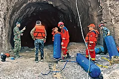
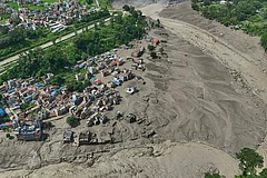

The affected area was around the Lhende River, about 20 km from the Rasuwagadhi crossing. ICIMOD and partner institutions found that large volumes of rock and ice entered the river, producing a violent downstream surge. More than 400 tourists remained missing, according to Nepal’s tourism ministry, while bridges and villages along the Bhote Koshi and Trishuli river systems were affected.

Uttarakhand Floods, 2025
On August 5, 2025, a sudden surge of water, mud, boulders and ice tore through Dharali in Uttarkashi, destroying homes, hotels and the marketplace along the Khir Gad stream. Dharali lies on the Bhagirathi River below a glacier-fed stream flowing from the Srikanta Glacier.
Initial explanations included a cloudburst, GLOF or extreme rainfall. However, an ISRO investigation identified a possible collapse of an exposed ice sheet more than 5,200 metres above sea level.
Satellite imagery showed bare ice patches in a high-altitude nivation zone below the glacier. The ice patch, spread over roughly a quarter of a square kilometre, suddenly collapsed. Located on a steep slope, the falling ice released meltwater, ice blocks and debris, which gathered more rocks, soil and old landslide material while moving downhill. It reached Dharali as a high-energy debris flood.

Nepal Floods, 2024
Between September 26 and 28, 2024, extremely heavy rainfall hit Nepal, particularly Kathmandu and nearby areas, triggering flash floods, landslides and riverine flooding. The Bagmati, Sapakoshi, Narayani, Sardu, Rew and Nakkhu rivers and their tributaries were affected. In total, 244 people were killed.
A World Weather Attribution study found that Kathmandu and Lalitpur were highly exposed because of their location in a valley with few natural drainage points. Built-up areas increased by 386% between 1990 and 2020, while forest cover declined by 28% between 1989 and 2019. The Department of Hydrology and Meteorology said rainfall at several stations was the highest in 54 years of measurements.
The study found that heavy three-day rainfall events had become about 18 per cent more intense and just over twice as likely, although uncertainty remained. Rapid urbanisation, deforestation and construction near floodplains increased vulnerability.

Sikkim GLOF, 2023
A massive collapse of rock, ice and sediment into South Lhonak Lake triggered the 2023 Sikkim GLOF, killing 55 people and destroying a 1,200-megawatt hydropower dam on the Teesta River.
A study published in Science journal, by 34 scientists and other stakeholders found no evidence that a cloudburst triggered the disaster, contrary to the Sikkim government’s attribution of the GLOF to a cloudburst. Researchers concluded that 14.7 million cubic metres of frozen lateral moraine collapsed into the lake at 5,200 metres above sea level. This produced a 20-metre-high tsunami-like wave and released 50 million cubic metres of water.
The GLOF then eroded about 270 million cubic metres of sediment, overwhelming infrastructure downstream. Researchers found the moraine was unstable, with maximum displacement of 15 metres a year between 2016 and 2023. The study also warned that continued warming could increase the threat from GLOFs.

Chamoli Flash Flood, 2021
On February 7, 2021, a massive flash flood swept through Uttarakhand’s Chamoli district, ravaging the valleys of the Rishi Ganga, Dhauliganga and Alaknanda rivers. More than 70 people were confirmed dead and another 134 reported missing.
The flood swept away the unfinished Tapovan Vishnugad Hydropower Project and damaged the Rishi Ganga Hydropower Project. In the immediate aftermath, a glacial lake outburst flood was suggested as a possible cause, with some reports describing it as a “glacier burst”.
ICIMOD initially withheld a conclusion on the cause while rescue and relief operations continued and available information was verified. Its subsequent report examined the cause and downstream propagation of the flood, along with the cascading nature of floods and challenges posed by infrastructure development.
The disaster occurred in a high-altitude region of steep terrain, glaciers and snow peaks, where hydropower projects have been developed because of perennial water sources.
Uttarakhand Floods, 2013
Between June 13 and 17, 2013, Uttarakhand received an unusual amount of rainfall, causing massive flash floods and landslides. The disaster affected large parts of Uttarakhand, Himachal Pradesh and western Nepal, with the Kedarnath valley among the worst-hit areas.
More than 5,000 people were killed. Ecologist Chandra Prakash Kala estimated the damage to bridges and roads at $285 million, with dam projects worth $30 million and state tourism losses of $195 million.
The region attracts thousands of pilgrims to sites including Badrinath, Kedarnath, Gangotri, Yamunotri and Hemkund Sahib, despite its susceptibility to earthquakes, landslides and flash floods.
Environmentalists argued that unplanned construction, mismanaged tourism and intensive mining increased the scale of the disaster. Roads, hotels and lodges had expanded into remote mountain areas to meet rising religious tourism. The unusual timing and volume of rainfall also left little time for evacuation.
What Does Research Say About Himalayan Flash Floods?
A research paper published in Nature, titled “Understanding Flash Flooding in the Himalayan Region: A Case Study”, says the Himalayas are prone to flash-flooding incidents because of their immense size and distinctive geological features.
The study identifies both natural and human-induced factors, including tectonic activity, glacial lakes, deforestation and changes in land use. In Uttarakhand’s Nainital region, it says, cloudbursts accompanied by heavy rainfall are often attributed as the primary cause of flash floods.
The research also highlights the role of rainfall products and remote-sensing data, including total aerosol optical depth, cloud-cover thickness and total precipitable water vapour, in real-time monitoring of short-lived flash floods.
Elevation, the study notes, plays an important role in influencing rainfall and temperature variations. Satellite technology and geospatial data can therefore help in tracking and responding to flash-flood events.