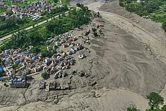
Nepal’s Rasuwa district flash flood killed at least 165 people, left around 1,000 missing, including 300 Indians, and damaged homes, bridges, roads and hydropower infrastructure.
The disaster highlights Nepal’s vulnerability to flash floods caused by intense rainfall, cloudbursts, landslides and possible glacial lake outbursts in steep Himalayan terrain.
A Nature study links Himalayan flash floods to geological and human factors, stressing satellite monitoring, scientific research, sustainable land use and resilient infrastructure.
A devastating flash flood in Nepal’s northern Rasuwa district near the Tibet border has once again highlighted the Himalayan nation’s extreme vulnerability to sudden and destructive floods.
At least 165 people have died, while around 1,000 people remain missing, including 300 Indian nationals, after floodwaters swept away homes, vehicles, bridges and infrastructure sites. Authorities in Bihar have also been placed on alert as the water moves downstream.
Unlike conventional floods, which can develop over hours or days, a flash flood is a rapid and sudden surge of water, often arriving with little warning.
It can be triggered by intense rainfall, a cloudburst, landslides blocking and then releasing a river, or the sudden bursting of a glacial lake. In mountainous terrain, water races downhill through narrow valleys, gaining enormous speed and destructive power.

Why Was The Rasuwa Flood So Destructive?
The Rasuwa disaster appears particularly unusual because Nepal’s Flood Forecasting Division said heavy rainfall within the district was unlikely to have been the sole cause. Satellite imagery, however, detected significant rainfall on the Tibetan side.

Authorities are also investigating whether a glacial lake outburst flood, or GLOF, may have contributed to the disaster.
The Bhote Koshi, where the latest disaster occurred, begins in Tibet before rushing through Nepal and joining the Trishuli river system. The water eventually reaches India through the Gandak river, meaning a disaster high in the Himalayas can quickly become a transboundary threat.
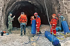
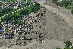
The latest flooding has devastated villages, the Timure border market, roads, bridges and hydropower infrastructure. Rescue helicopters have also struggled to land because of high water levels.

Why Is Nepal Vulnerable To Flash Floods?
Nepal’s geography makes it exceptionally prone to such events. The country lies in the young and geologically active Himalayas, where steep slopes feed thousands of fast-flowing rivers.
Heavy monsoon rain can quickly funnel into narrow valleys, transforming relatively small streams into raging torrents. The same geography that concentrates water also leaves roads, bridges, settlements and infrastructure exposed to fast-moving floodwaters, mud and debris.
Climate change adds another layer of risk. Himalayan glaciers are retreating, leaving behind expanding glacial lakes held back by fragile natural walls of ice and rock. A landslide, avalanche or sudden inflow of water can destabilise these barriers, releasing massive volumes of water downstream.
The region has suffered similar devastation before. Last year’s deadly Bhote Koshi flood washed away a bridge linking Nepal and China and was later linked to the drainage of a supraglacial lake in Tibet.

What Does Research Say About Himalayan Flash Floods?
A research paper published in Nature, titled “Understanding Flash Flooding in the Himalayan Region: A Case Study”, says the Himalayas are prone to flash-flooding incidents because of their immense size and distinctive geological features.
The study identifies both natural and human-induced factors, including tectonic activity, glacial lakes, deforestation and changes in land use. In Uttarakhand’s Nainital region, it says, cloudbursts accompanied by heavy rainfall are often attributed as the primary cause of flash floods.
The research also highlights the role of rainfall products and remote-sensing data, including total aerosol optical depth, cloud-cover thickness and total precipitable water vapour, in real-time monitoring of short-lived flash floods.
Elevation, the study notes, plays an important role in influencing rainfall and temperature variations. Satellite technology and geospatial data can therefore help in tracking and responding to flash-flood events.

Why Does Himalayan Infrastructure Remain At Risk?
The Nature study calls for a comprehensive approach involving climate-change mitigation, sustainable land-use practices and more resilient infrastructure. It also stresses the importance of continuous monitoring, scientific research and community engagement in preparing for extreme weather events.
For Nepal, the challenge lies in a landscape where mountains, monsoon weather, unstable terrain and a warming climate can combine to produce destructive floods within minutes. The latest disaster has again underlined the need for preparedness and infrastructure capable of withstanding these rapidly developing hazards.