Bhutan's October 29 glacial lake outburst damaged infrastructure and triggered evacuation alerts in parts of West Bengal and Assam.
Rising temperatures and retreating glaciers are contributing to the formation and expansion of glacial lakes across the Hindu Kush Himalayas.
GLOF monitoring, early-warning systems and downstream preparedness are crucial to reducing risks to Himalayan communities.
A glacial lake outburst in Bhutan on October 29 triggered a sudden flood that damaged infrastructure around the Gasa Tshachu natural hot springs and prompted evacuation alerts in parts of West Bengal and Assam. No deaths or injuries were reported in Bhutan, while floodwaters later passed through West Bengal's Sankosh river without causing major inundation. The incident has renewed attention on the risks posed by glacial lakes across the Himalayas, where retreating glaciers and changing mountain conditions are exposing downstream communities and infrastructure to sudden floods.
The outburst originated at Sintaphu Lake in Bhutan's Gasa district. West Bengal's chief irrigation engineer said authorities had anticipated around 7.4 million cubic metres of water, based on information from Bhutan's National Centre for Hydrology and Meteorology (NCHM) relayed through the Central Water Commission. ICIMOD separately estimated that the lake contained 6–7 million cubic metres before the outburst, while the volume actually released remained under assessment.
What are glacial lake outburst floods (GLOFs)?
A glacial lake outburst flood, commonly known as a GLOF, occurs when water stored in a lake formed by a glacier is suddenly released. Such lakes can develop in front of, on top of or beneath glaciers as ice melts and water collects in depressions. They may be held back by ice, natural barriers made of glacial debris or bedrock.


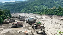
According to The Indian Express, moraine barriers can consist of sand, silt, gravel, pebbles and boulders deposited by glaciers. These accumulations are known as moraines.
When a natural barrier fails, erodes or is overtopped, large volumes of water can rush down mountain valleys in a short period. The flood may carry rocks, mud and other debris, damaging roads, bridges, settlements and hydropower infrastructure.
The October 29 outburst illustrates this risk. Reuters reported that the flood from Shintaphu Lake damaged infrastructure at Gasa Tshachu, a natural hot springs destination in northern Bhutan. Two Bailey bridges may also have been washed away, while part of the road connecting the area to Laya village was damaged and rendered impassable. The area had been evacuated before the floodwaters arrived. State broadcaster BBS said the full extent of the damage could not immediately be assessed because of the “darkness and the strong flow” of the water.
Why are GLOFs a concern in the Himalayas?
Rising temperatures are causing glaciers across the Hindu Kush Himalayas to lose ice and retreat. As glaciers recede, meltwater can accumulate in depressions, forming new lakes or expanding existing ones. ICIMOD's 2026 assessment found that glaciers across the Hindu Kush Himalayas lost around 12 per cent of their area and 9 per cent of their estimated ice reserves between 1990 and 2020.
A GLOF can be triggered by different processes. Heavy rainfall can increase the volume of water entering a lake. Landslides, rockfalls or avalanches falling into a lake can displace water, generate waves and cause it to overtop its natural barrier. Changes in the barrier itself can also lead to failure.
A 2026 study published in Natural Hazards and Earth System Sciences used an existing inventory of 2,574 glacial lakes in Bhutan, based on 2020 data, and selected 278 for detailed flood modelling. The researchers assessed the potential exposure of buildings, roads and farmland downstream.
The danger is not limited to Bhutan. In October 2023, a GLOF from South Lhonak Lake was identified as the primary cause of the sudden surge in the Teesta river, according to the Ministry of Home Affairs. The flood damaged bridges, settlements and hydropower infrastructure across the river basin and caused substantial loss of life.
How can a GLOF affect areas far downstream?
Water from the Sintaphu outburst entered the Mo Chhu river system. At Punakha, the Mo Chhu joins the Pho Chhu to form the Punatsangchhu, which flows into India as the Sankosh. The potential rise in water levels prompted Indian authorities to issue warnings for vulnerable areas in West Bengal and Assam.
The New Indian Express reported that the Union Ministry of Jal Shakti warned of a possible sudden rise in the Sankosh in West Bengal's Alipurduar district and Assam's Dhubri district. West Bengal authorities asked residents in vulnerable riverbank areas to move to safer locations. Water Resources Investigation and Development Minister Nisith Pramanik said: “Everyone living in the catchment areas of the Sankosh river and all its connected tributaries has been asked to move to a safe distance immediately to protect their lives.”
The immediate threat in West Bengal later subsided. The Statesman reported that the floodwaters passed through the Sankosh without major inundation and that residents who had spent the night in relief shelters began returning to their villages on October 30.
Bhutan's NCHM subsequently reported that a newly formed lake, described in its advisory as an artificial lake, had appeared at Taktsemakhang, near the confluence of Sintaphu Chhu and Lungu Chhu/Gangchen Tag Chhu. It advised residents along the Mochhu and Punatsangchhu river valleys to remain vigilant and avoid riverbanks and flood-prone areas while authorities monitored the situation.
What can be done to reduce GLOF risks?
The NDMA recommends identifying potentially dangerous glacial lakes by assessing their size, natural barriers, surrounding glaciers and terrain. It also recommends satellite-based monitoring to track changes in lake levels and identify new water bodies, including through Synthetic Aperture Radar imagery during the monsoon.
Other measures include controlled drainage, outlet-control structures, pumping or siphoning water, and drainage tunnels through natural barriers. These interventions can be considered for lakes assessed as particularly dangerous, depending on their physical characteristics.
Early-warning systems involve monitoring river levels, issuing alerts and communicating with communities downstream about possible evacuations. The October 29 Bhutan outburst also prompted warnings in parts of West Bengal and Assam.