NVS-03 restores NavIC’s positioning, navigation and timing services after ageing satellites and atomic clock failures disrupted the system.
The second-generation satellite features indigenous atomic clocks and the L1 frequency band, which could improve compatibility with civilian navigation devices.
ISRO plans to launch NVS-04 within five months and NVS-05 within 10 months to strengthen the constellation and expand NavIC’s capabilities.
The successful launch of the NVS-03 satellite on October 30 has restored India’s indigenous satellite navigation system, NavIC, to its minimum operational configuration of four satellites. The launch marks an important step towards reviving the system’s positioning, navigation and timing services, which had been disrupted by the failure of onboard atomic clocks in older satellites.
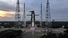
The Indian Space Research Organisation (ISRO) launched the second-generation navigation satellite aboard the GSLV-F18 rocket from the Satish Dhawan Space Centre in Sriharikota at 11:51 pm on Friday. The satellite was successfully placed in its designated transfer orbit.
ISRO Chairman V Narayanan said the satellite would help restore NavIC’s positioning, navigation and timing (PNT) services. Prime Minister Narendra Modi also congratulated ISRO scientists and engineers, describing the mission as an important step in strengthening India’s indigenous navigation capabilities and self-reliance in critical technologies.
But why does India need its own satellite navigation system, what had caused NavIC’s services to deteriorate, and how does NVS-03 address these problems?


What Is NavIC And Why Does India Need It?
NavIC, or Navigation with Indian Constellation, is India’s independent regional satellite navigation system. It provides positioning and timing information across India and a region extending approximately 1,500 kilometres beyond its geographical boundaries.
The programme emerged from the experience of the 1999 Kargil War, when India sought access to US Global Positioning System (GPS) data over the conflict zone to track Pakistani troop movements. The request was denied, exposing the risks of relying on a foreign-controlled navigation system during a military conflict.
The Indian government approved the Indian Regional Navigation Satellite System (IRNSS), which later became NavIC, in 2006. The original constellation was designed to comprise seven satellites: three in geostationary orbit and four in inclined geosynchronous orbit. ISRO launched the first satellite, IRNSS-1A, in July 2013, followed by six more between 2014 and 2016.
NavIC serves both civilian and strategic purposes. Its applications include vehicle and train tracking, maritime navigation, disaster management and the dissemination of safety-related information to fishermen operating offshore. It also provides two types of services: a Standard Positioning Service for civilian users and an encrypted Restricted Service for authorised users, including the armed forces.
An independent navigation system is particularly important for national security, as it reduces India's dependence on foreign systems for critical positioning and timing information.
Why Had NavIC’s Services Been Disrupted?
Although the original seven-satellite constellation was completed by 2016, the satellites were not designed to operate indefinitely. As the constellation aged, several satellites developed technical problems that affected their ability to provide navigation services.
One of the major challenges involved the satellites’ atomic clocks, which are essential for calculating precise location and timing information. IRNSS-1A lost the functionality of all three of its onboard rubidium atomic clocks between 2016 and 2017, restricting its use primarily to messaging services.
The problem persisted as other satellites approached the end of their operational lives. On March 13, 2026, ISRO announced that the atomic clock aboard IRNSS-1F had stopped functioning, three days after the satellite completed its 10-year design life.
This reduced the number of satellites capable of providing PNT services to three: IRNSS-1B, IRNSS-1I and NVS-01.
A navigation receiver generally needs signals from at least four operational satellites to calculate its three-dimensional position while correcting for errors in its own clock. With fewer than four functional satellites available for positioning, NavIC could no longer provide standalone positioning services in its intended configuration.
The disruption highlighted the importance of replacing ageing satellites and maintaining a sufficient number of operational spacecraft to ensure continuity of services.
How Does NVS-03 Help Restore NavIC?
To replace ageing satellites and improve the system's capabilities, ISRO began developing a second generation of navigation satellites under the NVS series.
The first satellite in the series, NVS-01, was launched in May 2023 aboard the GSLV-F12 rocket. However, the second satellite, NVS-02, encountered a technical problem after its launch in January 2025 and could not reach its intended operational orbit.
A subsequent investigation found that the drive signal had not reached the pyro valve in the oxidiser line of the engine used to raise the satellite's orbit. In February 2026, ISRO identified a connector-related issue as the most likely cause.
Against this backdrop, the successful deployment of NVS-03 is significant. Launched aboard GSLV-F18, the satellite brings the number of operational NavIC satellites providing PNT services back to four, restoring the system to its minimum operational configuration.
ISRO Chairman V Narayanan said the agency had taken additional precautions to avoid a recurrence of the technical problems encountered during the NVS-02 mission. The NVS-03 satellite was operated with three pyro valves already open, a decision validated following vibration and shock testing by a national-level committee chaired by former ISRO chief Kiran Kumar.
The launch vehicle also placed the satellite into its designated orbit with high precision, according to Narayanan.
What Is New About The NVS Series?
The NVS satellites are designed to improve the reliability and capabilities of NavIC.
One of their key features is the inclusion of indigenous atomic clocks alongside procured clocks. These clocks are crucial to the precise timing measurements required for satellite navigation.
The newer satellites also introduce the L1 frequency band alongside the existing L5 and S bands. The L1 band is widely used by civilian satellite navigation systems and could improve NavIC's compatibility with smartphones and other consumer navigation devices.
This is important because wider compatibility could make India's indigenous navigation system more accessible to ordinary users, rather than limiting its applications to specialised equipment and infrastructure.
However, the launch of NVS-03 does not mean NavIC's entire planned constellation has been restored. ISRO aims to expand the system further through the deployment of additional NVS satellites.
How Is NavIC Used By Civilians?
NavIC already supports several applications that require real-time positioning and tracking.
According to Narayanan, approximately 10,400 locomotives and 64,000 fishing vessels are being tracked in real time using the system. ISRO aims to increase the number of fishing vessels covered to one lakh within the next six months under the Pradhan Mantri Matsya Sampada Yojana.
Around 15 lakh tracking devices have also been fitted across vehicles.
For fishermen, satellite navigation and safety-related information can help support offshore operations. For transport and logistics, tracking technology can improve the monitoring of vehicles, trains and shipping vessels.
NavIC also has applications in disaster management, where accurate positioning and timing information can support coordination and response efforts.
However, the wider availability of NavIC on civilian mobile phones remains dependent on further development. Narayanan said that the system would become available on civilian smartphones once the full seven-satellite constellation is completed.
What Happens Next?
The launch of NVS-03 is an important step in restoring NavIC's operational capabilities, but maintaining the system will require continued replenishment of its satellite constellation.
According to Narayanan, ISRO plans to launch NVS-04 within five months and NVS-05 within 10 months. These satellites are expected to further strengthen the system and improve the continuity of navigation services.
The agency also plans to undertake five more launches during the current financial year, including the first uncrewed mission under the Gaganyaan human spaceflight programme.
For India, the significance of NVS-03 extends beyond a successful rocket launch. It addresses an immediate gap in the country's independent navigation infrastructure while advancing efforts to improve its reliability, expand civilian applications and reduce dependence on foreign-controlled systems.
The next challenge will be to sustain the constellation and complete its expansion so that NavIC can provide more reliable services to strategic users, transport networks and the wider public.