Experts say the Nepal floods underscore the need for scientific assessments of glacial lakes, downstream risks and potential triggers such as avalanches, landslides and extreme rainfall.
Researchers warn that warning systems focused mainly on rainfall may miss sudden flood events triggered by ice-rock avalanches or glacial activity.
Experts also call for stronger land-use policies and risk-based planning to prevent settlements and critical infrastructure from being built in vulnerable Himalayan areas.
The devastating flash floods in Nepal have driven home important lessons of undertaking systematic scientific assessments of glacial lakes in order to understand and mitigate the hazard and to develop a land use policy in the Himalayan region, experts said.
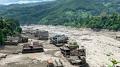
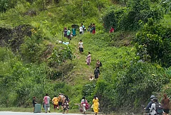
Two hundred seventy people have been killed and thousands including 288 Indian tourists are missing after massive flash floods hit parts of Nepal on Wednesday, wreaking havoc across several towns and villages, washing away critical bridges and crippling a dozen hydropower projects.
Researchers from the International Centre for Integrated Mountain Development (ICIMOD), based near Kathmandu, are investigating whether an ice-rock avalanche originating from a high-altitude location may have triggered the floods.

How The Flood Surge Began
A large volume of ice and rock debris may have entered the Lende Khola, a tributary of the Bhote Koshi River, which could have generated a sudden surge carrying water, sediment and large boulders downstream, they said, based on a preliminary assessment of video footage and information from affected areas.


"It is related to climate change because the snow covers are reducing, the glaciers are receding, more rocky or barren areas are exposed -- they absorb more heat which makes the slopes more vulnerable," Mohd Farooq Azam, senior cryosphere specialist at ICIMOD and associate professor at the Indian Institute of Technology Indore, told PTI.
Even though the exact cause is yet to be ascertained, he added, it may be a result of less snow cover, receding glaciers, and some permafrost degradation in the area.
Extreme precipitation events, especially heavy snowfall, in the Himalayas only temporarily increase snow accumulation, a study published in Global and Planetary Change has found.
Climate change has contributed to an increase in glacial lakes in Himachal Pradesh, with a recent study, published in the Journal of Hydrology: Regional Studies, showing an increase of 525 per cent in the lakes between 1990 and 2024, with a doubling in area. Smaller lakes have increased from nine in number to 487.
"There are different mechanisms through which glacial lakes can form. They may be dammed by moraines, glacier ice, bedrock depressions, or other geomorphological features," author Reet Kamal Tiwari, associate professor and head, department of civil engineering, Indian Institute of Technology Ropar, Punjab, told PTI.
However, the mere presence of a glacial lake does not necessarily mean that it poses an immediate threat to nearby communities, he said.
"We first need to assess the vulnerability and stability of the lake and identify the possible external triggers that could lead to a sudden release of water. The concern is not simply the increasing number of glacial lakes; it is the combination of increasing hazard potential and increasing downstream exposure," Tiwari said.
Triggers may include landslides, intense rainfall, snow or ice avalanches, rockfalls, or the collapse of a hanging glacier, he said.
Soniya Rijal, a postdoctoral research associate at the University of Sydney in Australia, said that a lack of warning system that is not built around rain also contributed to the disaster.
"What this event shows is that our warning systems, formal and informal, are built around rain. I have heard that people in the affected valleys were alerting their neighbours before the water arrived, but because there had been no heavy rainfall, many did not take the warnings seriously," she said. Rijal is from Kathmandu.

A Reminder Of Chamoli
The flash floods are similar to those in Chamoli, Uttarakhand, when a massive ice and rock avalanche from the Ronti peak triggered a sudden surge of water, impacting the Rishi Ganga, Dhauliganga, and Alaknanda rivers in February 2021. Hydropower projects were severely damaged and about 300 people, mostly workers at the dam sites, were reported killed or missing.
"Every disaster is unique. First, we need to understand the processes and then we need to design some mitigation measures accordingly," Azam said.
Tiwari said, "The first requirement is proper scientific assessment of potentially hazardous glacial lakes and their downstream areas." "A proper assessment should examine the lake, its dam and surrounding terrain, possible triggering mechanisms, downstream flow paths, and the settlements and infrastructure that could be affected," he said.
Authorities should involve experts with appropriate experience in glaciology, geomorphology, hydrology, remote sensing, geotechnical engineering, and disaster management, Tiwari added.
Further, the flash floods drive the urgency of developing land use policies, Azam said.
"The problem is we are settling very close to the river and sometimes on the river. The urgency is to develop a land use policy," he said.
"There should be proper planning for the settlement infrastructure development, because these events will happen and we understand that over the last couple of decades, the frequency as well as magnitude of such events have increased," he added.
Azam also pointed to how there needs to be an assessment of how environment can impact infrastructure.
"When we develop an infrastructure, we have to do environment impact assessment. But now is the time when we need to do environment's impact on the infrastructure," he said.
"If there is some heavy rainfall, some cloud burst, some glacial lake outburst flood, or something like what happened yesterday, what would be the impact on the settlement and infrastructure? So we don't have this kind of assessment anywhere," Azam said.