Latin America lies across some of the world's most active tectonic boundaries
Plate movements beneath the region generate frequent earthquakes, particularly along the Pacific coast
Population density, building quality, infrastructure and emergency response can dramatically increase the toll
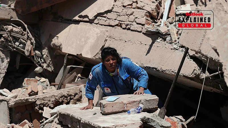
A 7.4-magnitude earthquake in Colombia killed at least 132 people and injured around 570, bringing the consequences of seismic activity into sharp focus. The earthquake was a reminder of a reality that extends well beyond Colombia: much of Latin America sits in one of the world's most active seismic regions.
The reason is not simply that the region lies within the Pacific Ring of Fire. Across Latin America, tectonic plates are constantly moving, colliding and being forced beneath one another. That movement generates earthquakes, while dense settlements, vulnerable buildings and secondary hazards such as landslides and tsunamis can turn seismic activity into a major disaster.
Why Does Latin America Have So Many Earthquakes?
Colombia's seismic activity is linked to the interaction of several tectonic plates, including the Nazca, South American and Caribbean plates. Its Pacific coast also lies within the wider Pacific Ring of Fire, a zone of intense seismic and volcanic activity.
The Ring of Fire describes the broader geographical setting; the earthquakes themselves are generated by the movement and interaction of tectonic plates.
The pattern extends far beyond Colombia. Along much of the Pacific margin of Latin America, oceanic plates are forced beneath continental or neighbouring plates. From Chile and Peru through Ecuador and Colombia and into Central America and Mexico, these plate boundaries generate some of the region's most significant earthquakes.




This process is particularly important along the western edge of South America, where the Nazca Plate is being subducted beneath the South American Plate. The same tectonic forces that helped form the Andes continue to deform the region and generate earthquakes.
The Andes are therefore not simply a mountain chain. Their formation and continuing deformation are closely linked to the tectonic processes that also generate earthquakes across the region.

Why Is Colombia So Vulnerable?
The Colombian Geological Service (SGC) says the country's geographical and geological setting makes it highly exposed to seismic hazards.
The SGC records roughly 80 earthquakes a day, or about 2,500 a month, although most are too small to be felt. The frequency of these events does not mean that Colombia experiences thousands of destructive earthquakes. Most earthquakes release relatively little energy or occur at depths and locations where they cause limited damage.
The greater concern is where a significant earthquake occurs and what surrounds it.
SGC material identifies several active seismic zones across Colombia and describes the country's complex tectonic setting. Earthquake hazard is therefore not confined to one part of the country.
The agency's seismic hazard assessments also show that a substantial portion of Colombia's territory has some probability of experiencing earthquake-related ground shaking at varying levels of severity. That is a probabilistic assessment of hazard, not a prediction that half the country will be devastated by earthquakes.
The distinction matters because earthquakes cannot currently be predicted in the way meteorologists forecast storms. Scientists can identify areas where earthquakes are more likely and estimate the probability of different levels of shaking, but they cannot reliably say when a particular major earthquake will occur.
When Does An Earthquake Become A Disaster?
An earthquake's magnitude alone does not determine its human impact.
The location and depth of the earthquake, the distance from populated areas, the quality of buildings and infrastructure, and the ability of emergency services to respond all influence the eventual death toll.
A strong earthquake in a sparsely populated area may cause comparatively little damage. A weaker earthquake beneath or near a densely populated city can be far more destructive.
Building quality is therefore crucial. Structures that are not designed to withstand seismic shaking can collapse, trapping or killing people even when the earthquake itself is not exceptionally large.
Population growth can compound the problem. As cities expand into areas exposed to seismic hazards, more homes, roads, hospitals and other critical infrastructure are placed in areas where ground shaking can cause damage.
This is why seismic risk is better understood as a combination of hazard and vulnerability. The movement of tectonic plates creates the hazard; human settlement and infrastructure determine how severely that hazard is felt.

The Danger Does Not End With The Shaking
Earthquakes can trigger disasters of their own.
In mountainous parts of Latin America, landslides can be among the most immediate consequences. Strong ground motion can destabilise slopes, bury roads and settlements and cut off communities from emergency assistance.
Colombia's geography makes this particularly important. Large parts of the country are mountainous, and earthquakes can destabilise already vulnerable terrain.
Water can create another threat.
An earthquake beneath or near the seabed can displace a large volume of water and generate a tsunami. For countries along Latin America's Pacific coast, this adds another layer of risk.
Colombia's own history shows that the threat is not theoretical. The SGC records major tsunami events associated with the 1906 magnitude 8.8 earthquake and the 1979 magnitude 8.1 earthquake. Together, the two events caused more than 1,000 deaths and extensive destruction along Colombia's Pacific coast.
A major earthquake can therefore produce a chain of disasters: the initial shaking can damage buildings, landslides can block roads and isolate communities, and coastal earthquakes can generate tsunamis.
Why Can't Scientists Prevent The Next Big Earthquake?
There is no way to stop tectonic plates from moving, and there is currently no reliable method of predicting exactly when a major earthquake will strike.
That makes preparedness the central defence.
Seismic hazard models allow authorities to identify areas with greater probabilities of damaging ground motion and establish building standards accordingly. Monitoring networks can detect earthquakes quickly and help authorities assess their location and magnitude.
But early detection is not the same as prediction. Monitoring can provide information within seconds or minutes after an earthquake begins; it cannot tell communities days in advance that a particular earthquake is going to happen.
The most effective protection therefore comes before the earthquake: stronger construction, enforcement of seismic building standards, emergency planning and public awareness.

Why The Region Keeps Facing The Same Risk
Latin America's seismic exposure is ultimately a product of geography that cannot be changed.
The region contains some of the world's most active tectonic boundaries, particularly along its Pacific margin. Colombia's position between the Nazca, South American and Caribbean plates gives it a complex seismic environment, while the wider Pacific coast from South America through Central America and Mexico remains exposed to powerful earthquakes generated by plate interactions.
But tectonic activity does not automatically produce a deadly disaster.
The scale of destruction depends on what lies above the fault when it moves: how many people are nearby, how buildings respond to shaking, whether roads and emergency services remain functional and whether secondary hazards such as landslides or tsunamis follow.
That is why the latest Colombian earthquake is not only a story about the power beneath the ground. It is also about the vulnerability above it.
The tectonic forces will continue to move. The real question is how prepared Latin America's cities and communities are when they do.