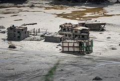
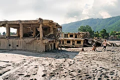
On August 26, 2026, a wall of mud, ice and rock tore down the Trishuli River basin along the Nepal-Tibet border, cutting a scar over a 100 km through Rasuwa and Nuwakot—Nepal’s deadliest extreme-flow disaster on record. It happened a day after the special representatives of India and China, Ajit Doval and Wang Yi, wrapped up the 25th round of boundary talks in Beijing, which mentioned trans-border rivers only in passing. Both sides agreed to “maintain communication” on data sharing and the renewal of the memorandum of understanding (MoU) ahead of a September meeting on trans-border rivers, with no reference to the Medog mega-dam that China began building last year barely 50 km from the Arunachal Pradesh border. The latest information suggests that the trigger for the disaster was a glacier-and-bedrock collapse on the Nepali side, and not a Chinese dam failure, as initially suspected in Nepal. But the more useful question is what it reveals about the Himalayan frontier’s worsening state and how India and China talk, or fail to talk, about even greater risks downstream.
The world’s youngest, most seismically active mountain range is changing fast. Warming at two to four times the global average, the Hindu Kush Himalaya now holds an estimated 25,600 glacial lakes, 47 rated at high outburst risk, with Glacial Lake Outburst Flood hazards projected to triple by the end of the century. This rapid thaw has triggered a sequence of disasters which are not isolated events: Uttarakhand’s Kedarnath (2013) and Chamoli (2021), Sikkim’s South Lhonak (2023), and, in Nepal, successive major floods at Thame (2024), Rasuwagadhi (2025), and now Trishuli. Scientists have cautioned against attributing any single disaster to climate change, but the trend is undeniable: risk is accumulating faster than regional institutions are learning to manage it.


Onto this fragility, China has layered two decades of frenetic construction across the Tibetan Plateau, South Asia’s water tower—superhighways, military airfields, high-altitude rail network, hydropower cascades, extensive tunnelling and fortified Xiaokang settlements—through some of the range’s youngest valleys. This strategy suffers from a fundamental flaw: engineering hubris in a dynamic and fragile mountain ecosystem. Every downstream state inherits whatever risk that adds, with no say in how or where it happens.
China’s conduct as an upper riparian nation poses growing regional challenges. Its unilateral hydro cascades on the upper Mekong have triggered unpredictable flows, seasonal droughts, declining fish stocks and sediment loss across the Lower Mekong Basin, affecting Myanmar, Thailand, Laos, Cambodia and Vietnam. South Asia faces a similar dynamic: an upper riparian country building faster and bigger at home while remaining reluctant to consult or share hydrological data with its neighbours.
China exhibits an entrenched habit of treating river data as a strategic asset.
India’s experience shows how extreme that reluctance has become. China suspended data-sharing on the Brahmaputra and Sutlej in 2022; the MoUs that once carried monsoon-season flow data have lapsed—they have not been renewed—and “there is no activity being undertaken” under the umbrella MoU (as per the Department of Water Resources, River Development and Ganga Rejuvenation website). China exhibits an entrenched habit of treating river data as a strategic asset that is shared—if at all—on Beijing’s terms.
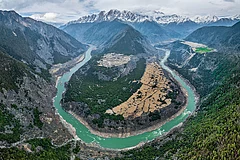
This opacity is most alarming on Medog. Without consulting lower riparian nations, China is constructing a 60-gigawatt, five-dam-cascade hydropower project near the Great Bend of the Yarlung Tsangpo, adjacent to Arunachal Pradesh, requiring four 20-km tunnels bored through the Namcha Barwa mountain peak to reroute the Yarlung Tsangpo/Brahmaputra. Designed to be the largest hydroelectric facility in human history, this project is located in Seismic Zone V within the Eastern Himalayan Syntaxis, a region that triggered the 1950 Assam-Tibet earthquake and a 6.8-magnitude tremor in January 2025.
Despite the current friction, history shows that transboundary risk management between India and China is possible. In June 2004, a landslide in Tibet dammed the Parechu, a Sutlej tributary, forming a lake holding an estimated 200-300 million cubic metres of water that threatened Himachal Pradesh’s Nathpa Jhakri project and the Bhakra Dam. As Joint Secretary (East Asia) in the Ministry of External Affairs then, I was involved in the engagement that followed: China shared rate-of-rise data, sent technical teams to the site and excavated a controlled spillway, while India drew down reservoirs, tracked the lake by satellite and evacuated vulnerable populations. When the barrier breached in June 2005, no lives were lost in India. That hard-won episode produced the India-China Expert-Level Mechanism (ELM) on transborder rivers.
The Way Ahead
The task now is to revive such cooperation at far higher stakes. The ELM will meet in September, but this cannot be another round of press-release language about “maintaining communication”. India should press for full technical details of Medog—cascade design, tunnel specifications, seismic modelling—and for its environmental impact studies to be shared, followed by inter-governmental consultations and a track-2 dialogue between experts of both countries. A project of this size, this close to the border, this seismically active, cannot proceed in secrecy. The meeting should also press for the renewal of the lapsed monsoon-data MoUs and a binding protocol covering lean-season flows and emergencies.
This disaster should also prompt Kathmandu to reassess infrastructure choices in fragile geographies. Rasuwagadhi and Upper Trishuli 3A have both been hit twice in 13 months, while the near-complete Upper Trishuli-1 dam suffered catastrophic damage. Preliminary estimates indicate that at least 13 hydropower projects—eight operational and five under construction—were damaged or submerged. Nepal must revisit the assumption behind this expansion that steep, glacier-fed border valleys are viable hydropower sites where risk can be managed after construction. The same applies with even greater force to the proposed Gyirong-Kathmandu rail link, long promoted by Beijing through this same corridor: questionable on economic merits even before the floods, given the tunnelling required and thin traffic, its vulnerability is now starkly exposed.
A similar review is urgently required on India’s side too. Approving projects on historical hydrological baselines while ignoring cumulative basin-wide risk turn power and strategic assets into liabilities. To credibly demand transparency from Beijing, New Delhi must lead by example, enforcing cumulative impact assessments and climate-resilient engineering across its own mountain frontiers.
What Parechu showed and what the September meeting should demonstrate again is that the two countries should manage this shared risk in cooperation. Existing mechanisms can be revived and strengthened; both sides have proved once that they can collaborate under real pressure. What has been missing since is not the capability, but the willingness to use those mechanisms before the next disaster. If China is serious about normalising relations and building trust with India, a litmus test lies here.
(Views expressed are personal)
MORE FROM THIS ISSUE

Ashok K. Kantha is former ambassador of India to China and Subhash Chandra Bose chair of International Relations at Chanakya University, Bengaluru