The Nepal-Tibet flood of August 26, 2026, has been described as a natural disaster caused by a glacier collapse. But treating it as an isolated act of nature undermines the larger pattern underneath it—a pattern the lower riparian state drawing water from the Tibetan plateau should be watching closely. This disaster raises fundamental questions: whether the accelerating pace of hydropower construction across Tibet is compatible with the seismic and glacial instability of the terrain it is being built on and whether downstream states have the institutional capacity to manage the risk that such ‘development’ creates.
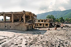
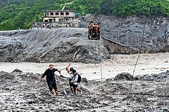
A section of the Langtang Lirung glacier, sheared away at an elevation of roughly 5,200 metres, generated a seismic signature of magnitude 5.2 as it collapsed into the Lhende Khola, sending a debris-laden surge across the border within minutes, destroying the Kyirong port complex before continuing downstream through the Bhote Koshi and Trishuli river systems. Nepal has recorded more than 1,100 fatalities, with nearly 4,000 people still missing. China, by contrast, has reported just 16 fatalities and 1,066 missing on the Tibetan side. Reports indicate that footage documenting the extent of the damage in Tibet has been restricted and deleted immediately.
This was neither the first failure on this river nor unforeseeable. It is a seven-decade pattern; more than 100 dated flood events have been documented from the 1954 Koshi Agreement through the ongoing Bhote Koshi disaster. In July 2025, a supraglacial lake roughly 36 km north of the Rasuwagadhi crossing destroyed the Nepal-China friendship bridge. Nepal and China subsequently agreed in principle to establish a real-time data-sharing mechanism for floods, landslides, and glacial lake outburst risk along their shared watersheds. Thirteen months later, in August 2026, that mechanism had not been formalised. Nepal's Flood Forecasting Division has confirmed that it received no warning as no cross-border alert system was in place.




A 2015 study in mountain research and development had already identified the Bod Chu/Bhote Koshi/Sun Koshi basin as highly prone to glacial lake outburst floods, and called for a monitoring and early-warning system that, more than a decade later, still does not fully exist. The International Centre for Integrated Mountain Development has separately documented that glaciers across the Hindu Kush Himalaya are now losing ice at double the rate recorded since 2000.
This pattern of underprepared infrastructure sitting atop underappreciated seismic and glacial risk is not confined to the Rasuwa corridor. It extends, at considerably greater scale, to China's flagship hydropower project on the Yarlung Tsangpo, the Metok hydropower project. Once
Metok dam is not simply a hydropower project, but it is a border-adjacent mega-structure only 30-50 km from the Line of Actual Control, and in one of the world’s most seismically active regions. China’s own state-owned geological survey warned that the terrain has a “loose structure and weak cohesion” where “after long-term immersion and under the influence of fault activity and earthquakes, instability of the slopes on both sides of the reservoir area can be extremely easily triggered”. Similar concerns were raised by a former Sichuan geology chief engineer, Fan Xiao, in 2022.
The real concern is not deliberate control of water, but the possibility of cross-border catastrophe. A run-of-river dam may not significantly regulate downstream flows, but it cannot eliminate the risks of earthquakes, landslides, ice-rock avalanches or glacial outbursts that could potentially create cascading effects downstream in India and Bangladesh.
Tibet functions as the headwater region for river systems supporting an estimated 1.8 billion people across China, India, Nepal, Bangladesh, Myanmar, Laos, Thailand, Cambodia and Vietnam. Yet, no binding framework currently governs real-time hydrological or seismic data-sharing between China and its downstream neighbours. Moreover, it is time to be far more proactive about what is happening across Tibet’s rivers, glaciers, lakes and dam projects. These are not simply matters of China’s domestic policy as the Tibetan plateau is a critical source of water for millions in the South and Southeast Asia. Downstream nations have a legitimate stake, and an urgent responsibility, in what happens upstream.
India has raised comparable concerns over Brahmaputra data-sharing for years, predating the Metok project itself. In fact, a 2016 Government of India document was explicitly titled ‘Impact of Dams Constructed by China’. It is a case for downstream nations to treat Tibet's rivers, glaciers and dams as their own legitimate concern rather than someone else's domestic policy.
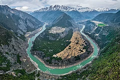
The devastating glacier collapse behind the recent Nepal-Tibet disaster is a powerful reminder of the growing vulnerability of the Tibetan plateau, the Third Pole. Tibet is warming at roughly twice the global average in recent decades, accelerating glacier retreat and permafrost thaw. But climate change is unfolding alongside another pressure: the intensive exploitation and transformation of Tibet’s fragile landscape through dam construction, mining, hydropower projects, roads, tunnels and other large-scale infrastructure. These activities disturb permafrost, destabilise slopes, fragment ecosystems and alter river systems, adding further stress to an already vulnerable environment. The lesson for downstream nations is clear: as Tibet’s ice retreats and its landscape is increasingly engineered and exploited, the risk of sudden cross-border water disasters cannot simply be ignored.
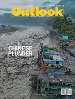
MORE FROM THIS ISSUE

(Dr. Tenzin Dolma is a Research Fellow at the Tibet Policy Institute. She holds a PhD in Education from O.P. Jindal Global University, with an academic background in public policy. Her current research focuses on Tibet’s ecology, with particular emphasis on the region’s river systems and their environmental and geopolitical significance.)