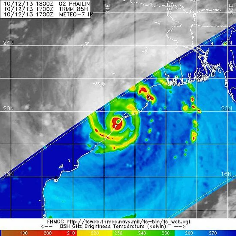
CyclonePhailin at landfall in Odisha
Does Phailin mean anything?
Yes. It means ‘sapphire’ in Thai. There exists an internationally agreed upon system to allow countries to suggest names for cyclones. Back in 1953, only names of women were used but protests led to masculine names also being accepted. However, some of the deadliest ones have had female names – Katrina, Nargis, Aila… It was Thailand’s turn this time around and it suggested ‘Phailin’, a common name for girls there.
How is a cyclone formed?
With evaporation, the vapours rise upwards along with warm air. This creates a low pressure zone, which is filled by surrounding air. As this process goes one, the earth’s rotation gives it a swirl and moist air clusters to form thunderstorms. The “eye of the storm”, the little hole you see at the centre of satellite images of the storm, is the zone with the lowest pressure.
Advertisement
Is Phailin a super cyclone?
Indian meteorological (IMD) department classifies a cyclone as a Super Cyclone when wind speeds associated with it touch above 220 km/h. The 1999 cyclone that claimed around 10,000 human lives was one. While international meteorological associations had initially forecast wind speeds up to 315km/h, the IMD predicted speeds less than 220km/h. This had led to some accusations of the IMD downplaying the threat. Some international experts such as Jeff Masters have suggested the IMD actually use sophisticated aircraft and fly them into the cyclone to get accurate measurements of the wind speed, something the Americans do.
Advertisement
First reports though suggest the IMD may have been more precise – wind speeds during landfall were reported to be around 200 km/h. This quibbling aside, Phailin remains one of the deadliest storms to hit the Indian Ocean since 1999.
What is the threat from cyclones, especially this one?
Fears of widespread destruction were raised because of three factors:
- A tidal surge – The IMD had predicted a tidal surge of around three metres above the astronomical tide after the cyclone makes landfall and ingresses. This could inundate low lying areas.
- Heavy rainfall – It was expected to rain as much as 25 cm in 24 hours. This could mean widespread flooding.
- Extremely strong winds – The IMD had forecast wind speeds up to 220 km/hr, with gusting to 235 km/h. This could easily destroy kutcha houses, standing crop, uproot trees and bring down power and communication lines. The good news though is that actual wind speed when the cyclone made landfall was around 200 km/h. The speed of the cyclone’s progression, on the other hand, was between 15-20 km/h.
What is Phailin’s size?
One of the main reasons for concern about Phailin’s impact is its size – around 2,00,000 sq kms in its spread and big enough to cover much of peninsular India. The one in 1999 was smaller in its spread comparison.
Is a comparison fair?
Meteorologists in India have chosen to steer clear of comparing the two cyclones, especially since observation capabilities were much poorer back in 1999. Still, some similarities can’t be wished away such as their common origin in the Pacific, landfall in the same month (October) and approximately the same zone of destruction.
Advertisement
What was the actual damage?
Mercifully, the loss of human lives was minimal. There have been conflicting reports of deaths from Odisha, and the toll so far is 15. Andhra Pradesh has reported no death so far. Loss to property, on the hand, has been extensive. This is largely because of prompt and reliable weather feedback and effective evacuation measures that saw over eight lakh people moving out of homes into concrete structures, like schools, for shelter. There was also a stroke of luck as the cyclone did not aggravate into a super cyclone.
Advertisement
What is the challenge ahead?
Immediate focus is is on opening blocked roads due to fallen trees and other debris. Food, clean drinking water, restoring power and communication lines are another necessity. Relief packages for loss of property and rehabilitation of affected families are some of the long-term challenges.
Why is the Indian Ocean so vulnerable to extreme weather events like cyclones?
One estimate suggests that 26 of the 35 deadliest cyclones in the past 200 years have occurred in the Indian Ocean basin. This is because, as director of the Indian Meteorological Organisation L.S. Rathore explained to this correspondent, the basin is much warmer than others. Moreover, the cyclogenesis process is aided by the basin proximity to the Pacific Ocean, another vulnerable zone.
Advertisement
How were we better prepared for Phailin than we were for the one in 1999 (simply called Cyclone 05B)?
A major difference is the dramatic improvement in forecasting capabilities. Unlike back then, when India was caught off-guard with just about a day’s notice, this time the first “cyclone” warning was out three days before the cyclone made its landfall. This has come about largely due to better observational capabilities from the space and in the ocean using satellites and buoys respectively. This has been combined with better weather modelling support and processing tools. The advance warning using these technologies gave the authorities much more time to plan and evacuate people to safer zones. A total of more than eight lakh people were moved, making this one of the biggest peace-time evacuation processes.
Advertisement
How long will the impact last?
For at least 12 hours after landfall, as it moves inward towards northeast Chhattisgarh, south Jharkhand and eastern UP. This will cause heavy rainfall in these areas on Sunday night/Monday.
Also See:
- Cyclonewatch: Phailin Updates
- From the archives: 1999 Cyclone Coverage