An adventurous trekker's delight, the green carpeted Naga Hills that surge to 2,000 feet from the Brahmaputra valley rise further to form Mount Saramati, at an elevation of 12,602 ft, the state's highest peak. This is also where the Naga Hills merge with the Patkai range, which borders Myanmar. The mountain range Pat-kai-chang-kan or 'oath taken by sacrificing a fowl,' was known in ancient times as Daikaorang or nine mountains. A haven for flora and fauna of the evergreen tropical and sub-tropical variety, Nagaland's wooded forests are intriguing for the avid trekker. The hills provide routes for amateurs and professional trekkers; advance preparations regarding permissions, weather, safety, and shelter are required. Here are six trekking routes that will have you mesmerised and returning for more.
Advertisement
Pungro
This route, via Thanamir or 'apple' village in the Kiphire district, will give you a view of the snow-clad Mt Saramati peak. An arduous trek, and not for the weak-limbed, it provides breathtaking views of the mist-covered surrounding hills comprising forests, meadows, and patches of jhum cultivation. Fields of flowers and rolling clouds will greet you as you approach the tops of the Patkai range. If you trek through here in early September, you can enjoy the apple festival in Thanamir village.
Japfu
Around 15 km from Kohima lies Mt Japfu, the second-highest peak of Nagaland after Mt Saramati. Set at an altitude of 3,054 m above sea level, it has, as per the Guinness World Records, 2007, the tallest rhododendron tree in the world, measuring 109 feet in height. One of the most challenging treks in Nagaland draws trekkers and adventure-seekers from across the globe. The Japfu trek begins at the Japfu Christian College in the village of Kigwema.
Advertisement
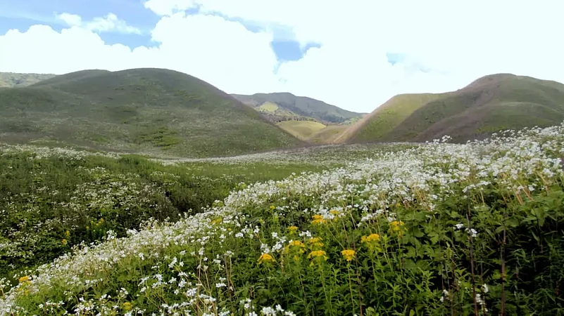
Dzukou Valley
One of the must-visit sites of the state, the Dzukou valley in the Kohima district, is a trekker's paradise. Also known as the valley of flowers for the Lilium, Mackliniae, Caltha palustris, Anemone revelries, and Euphorbias blooms that appear here between April and September and reach a crescendo in the early weeks of July.
Mokokchung
Inhabited by the Ao Nagas, Mokokchung is also known as the Land of Pioneers and is located at a height of 1,325 m above sea level. There are several areas available for trekking-based activities. One of these is angling in the Milak and Tzula rivers.
Mount Tiyi
Situated at an altitude of 1,969.61 m above sea level, the Wokha district, the Mt Tiyi trek will take you past rhododendron forests, which is a treat. The peak offers a birds-eye view of the district, the name of which means 'census' in the Lotha tribe language. It was a place where the Lotha counted heads before migrating into the surrounding areas. It is believed by the tribes Sema, Ao, and Lotha that the mountain is the home of the souls of their ancestors. Apart from trekking on Mt Tiyi, you can also indulge in rock climbing and its associated activities.
Advertisement
Satoi Range
This bio-diversity region, located in the Zunheboto district or the Land of Warriors, is one of Nagaland's only remaining unspoiled forests. The Satoi range is home to the endangered bird Blythe's Tragopan. The woodlands of Satoi also shelter the Western Hoolock Gibbon, Chinese Pangolin, and Great Hornbill. Trekking and similar activities are readily available here, although required permissions have to be taken.