Assam floods have killed 58 people and affected nearly seven lakh residents.
Extreme rainfall rapidly swelled the Brahmaputra and several major tributaries.
Climate change, erosion and siltation are intensifying Assam’s annual flood crisis.
Assam Floods Explained: Why The Brahmaputra Is Swelling Beyond Control
At least 58 people have died and around seven lakh residents affected across 856 villages in 12 districts due to floods.

Summary
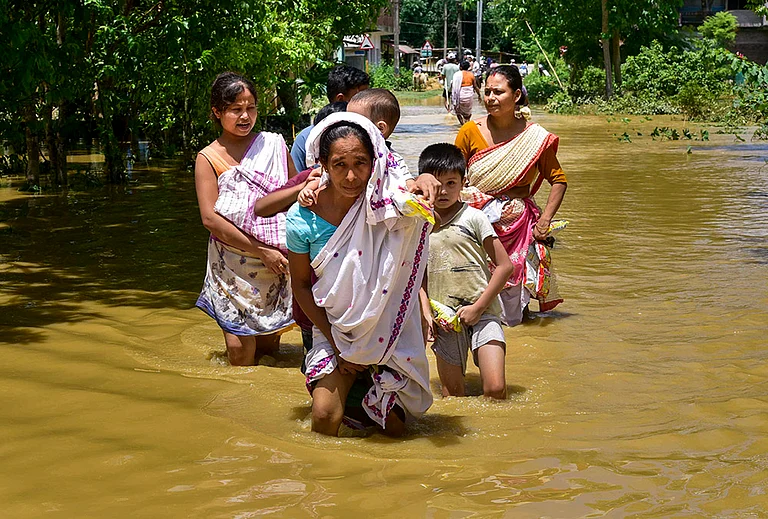
Assam is facing one of its most destructive floods in recent years, with at least 58 people killed and around seven lakh residents affected across 856 villages in 12 districts.
The worst impact has been reported from the Upper Assam districts of Sivasagar, Charaideo and Jorhat, where residents say floodwaters have entered areas that were previously considered relatively safe. Major towns, agricultural fields and entire villages have been submerged, while more than 1.15 lakh people have taken shelter in relief camps.
The disaster has exposed how extreme rainfall, the Brahmaputra’s geography, growing sedimentation and long-term ecological damage are combining to make Assam’s annual floods increasingly dangerous.
Why Are Assam's Floods So Severe This Year?
Floodwaters began rising rapidly around July 19 after intense rainfall in Nagaland and Assam’s foothill regions. Rivers flowing through Upper Assam crossed danger levels within a short period, leaving little time for evacuation and relief operations.
According to the Assam government, rainfall over July 18 and 19 was far above normal in parts of Nagaland and Assam. Charaideo recorded a 436 per cent departure from normal rainfall, while Mokokchung in Nagaland saw a 493 per cent departure.
Chief Minister Himanta Biswa Sarma described the speed at which water levels rose as “unprecedented”. Even after water began receding, thick layers of sand and sediment blocked roads and paths, preventing relief teams from reaching several flooded areas.
Around 4,455 people have been evacuated by the National Disaster Response Force, the Army, the State Disaster Response Force, fire services and local administrations. However, authorities have warned that the death toll could rise as access improves.

How Extreme Rainfall Swelled Brahmaputra And Its Tributaries?
The Assam government initially linked the floods to a “cloudburst” in Nagaland’s Mon district. However, an official from the Meteorological Centre Kohima told The Indian Express that the region had not experienced a cloudburst as defined by the India Meteorological Department.
The IMD classifies rainfall exceeding 100 mm within an hour as a cloudburst. Mon instead received around 137 mm of rain over eight to nine hours, which was still intense enough to trigger landslides and sharply raise river levels.
Advertisement
The rainfall swelled tributaries such as the Dikhow, Disang and Dhansiri. As of Friday, these rivers were classified as being in a “severe flood situation” at multiple monitoring stations.
The already swollen Brahmaputra also slowed the discharge of water from its tributaries, causing water to back up and spread across low-lying areas.
Why Assam is Naturally Vulnerable To Floods?
Assam lies almost entirely within the floodplain of the Brahmaputra, one of the world’s largest river systems.
The river originates on the Tibetan plateau, enters India through Arunachal Pradesh and flows across Assam before reaching Bangladesh. More than 50 tributaries join it along the way, carrying rainwater, snowmelt, sand and silt from the Himalayan and northeastern hills.
The Assam government estimates the Brahmaputra’s average annual discharge at around 20,000 cubic metres per second. During the monsoon, this volume rises sharply.
Assam also receives around 2,800 to 3,000 mm of rainfall annually, with nearly 70 per cent falling during the southwest monsoon between June and September. Its low-lying terrain and dense river network therefore make seasonal flooding a natural occurrence.
Advertisement
How Climate Change Is Making Rainfall More Erratic
Climate change is increasing the frequency of short, intense rainfall spells that can overwhelm rivers, drainage systems and embankments.
Instead of rain being distributed evenly across the monsoon season, large volumes are increasingly falling within a few hours or days. Such events can rapidly raise river levels, trigger landslides and leave authorities with little time to issue warnings or conduct evacuations.
Experts have warned that high-intensity rainfall events exceeding 50 mm or 100 mm in a day are likely to become more frequent as temperatures rise.
The Role of Erosion, Siltation And Encroachment
The Brahmaputra carries enormous quantities of sediment from the Himalayas. After entering the Assam plains near Pasighat, the river’s slope becomes gentler, reducing its ability to carry sand and silt.
Advertisement
This sediment settles on the riverbed, reducing its water-carrying capacity and pushing water towards surrounding floodplains.
Deforestation in upstream hill regions has worsened soil erosion and increased the amount of loose material entering rivers. Encroachment on wetlands, river channels and natural drainage routes has further reduced the space available for floodwaters to spread safely.
Published At: