South India weather forecast dominated by Cyclone Senyar and a well-marked low-pressure system; heavy rain forecast for Tamil Nadu, Kerala, and Andhra Pradesh.
Bengaluru weather remains mild with partly cloudy skies today; significant rainfall is expected by November 29 with a temperature drop.
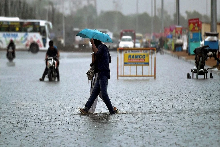
Chennai Weather Today sees potential heavy spells; widespread very heavy rainfall warning issued for Tamil Nadu through December 1.
IMD alert warns of squally winds (45-55 kmph) and rough seas; fishermen are advised against venturing into the Bay of Bengal.
South India Weather Forecast: Cyclone Senyar and Low-Pressure System Trigger Heavy Rain Alerts
South India faces a heavy rain forecast as Cyclone Senyar and low pressure system combine. Tamil Nadu and Andhra are on alert; Bengaluru expects weekend downpours. Fishermen warned of rough seas.

Summary
The South India weather forecast for November 27, 2025, is heavily influenced by two significant atmospheric systems: Cyclone Senyar positioned near the Strait of Malacca and a well-marked low-pressure area intensifying over the southwest Bay of Bengal. These systems are collectively triggering a widespread heavy rain forecast across southern peninsular India. The India Meteorological Department (IMD) has issued comprehensive alerts for Tamil Nadu, Kerala, Coastal Andhra Pradesh, and the Andaman & Nicobar Islands.
While Chennai Weather Today indicates cloudy skies with intermittent heavy spells, the intensity of precipitation is expected to escalate dramatically over the coming 48 hours. Bengaluru weather currently offers a contrast, with partly cloudy skies and comfortable temperatures, though meteorologists predict a significant shift with heavy showers arriving by the weekend. The convergence of these weather systems has prompted authorities to issue warnings for rough sea conditions and potential disruptions to daily life in coastal districts.
City-wise Weather Impact and Forecast
Chennai and Tamil Nadu: The capital city faces immediate rainfall prospects with temperatures ranging between 25°C and 29°C. A red alert equivalent warning suggests widespread "heavy to very heavy" rainfall across coastal districts from November 28 to 30, driven by the deepening low-pressure system. Northern districts may receive up to 21 cm of rainfall, significantly reducing the seasonal deficit.
Bengaluru and Karnataka: The Garden City enjoys a temporary respite with maximum temperatures around 28°C and minimums near 19°C. Skies remain partly cloudy today, but Bengaluru weather forecasts indicate a sharp turn by November 29, with an 80-90% chance of heavy rain and temperatures dropping to 15-20°C. The rest of Karnataka will largely experience dry conditions before the wet spell encompasses the southern interior regions.
Hyderabad and Andhra Pradesh: Hyderabad maintains warm daytime conditions around 30°C with pleasant nights at 19°C. However, coastal Andhra Pradesh, particularly Yanam and Rayalaseema, faces a "heavy to very heavy" rainfall alert for November 29-30 as the weather system moves northward.
Cyclone Senyar and Marine Warnings
Cyclone Senyar, currently moving west-southwestwards, is expected to maintain its intensity before recurving eastwards. While it poses no direct landfall threat to the Indian mainland, its presence reinforces the moisture incursion feeding the rainfall activity. The IMD alert specifies squally weather with wind speeds reaching 45-55 kmph, gusting to 65 kmph, over the Southwest Bay of Bengal, Gulf of Mannar, and off the Tamil Nadu-Sri Lanka coasts. Fishermen are strongly advised to avoid these sea areas through November 30 due to "rough to very rough" sea conditions.
Advertisement
Authorities have activated emergency protocols in coastal Tamil Nadu and Andhra Pradesh, anticipating potential waterlogging and localized flooding as the dual weather systems amplify rainfall intensity over the weekend.
Published At:
Tags