
Itanagar
The picturesque town of Itanagar, Arunachal Pradesh’s capital, is located in the southern foothills of the Himalayas. Pleasant weather, rich biodiversity, and vast stretches of breathtaking landscapes make Itanagar a superb destination for long holidays, throughout the year. Home to a large number of Nyishi tribals who speak a language of Sino-Tibetan origin, the city is known for its unique culture and friendly populace.
A visit to the city’s Craft Centre and Emporium is the best way to acquaint yourself with the impressive collection of handicrafts that Itanagar has to offer. Itanagar also has a bustling market, where visitors can browse through a range of handicrafts from across the state.
Things to See & Do
Itanagar was declared the capital of Arunachal Pradesh in 1974. Situated at an elevation of 350m, the quaint town is renowned for its fine Tibetan architecture and varied tribal culture.

Ita Fort
Constructed in 15th century CE by the Ahom dynasty, Ita Fort lends its name to this town. The fort is in the centre of the Capital Complex and has three magnificent entrance gates. It was an imperial structure, and is said to have been constructed using 80 lakh bricks. Now, only the ruins remain, standing amidst sprawling gardens and offering splendid views of the city.
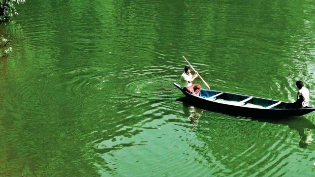
Ganga Lake
Also known as Gyakar Sinyi, this popular picnic spot is 7km from the city. The charming lake is surrounded by thick forests. The lake is frequented by locals and visitors alike, but still manages to remain serene, enabling one to enjoy solitude. You can carry some food and feed the fish in the lake, and even enjoy a boat ride.
Adventure Activities
The city and its outskirts offer plenty of outdoor activities such as rafting, trekking and angling. Trekking is a popular activity here, with Itanagar-Pashighat being a famous trail. It passes through Ziro and Daporijo. Other trails are the Jong-Tawang and the Jorhat-Tawang trails.
Wildlife enthusiasts will enjoy exploring the Itanagar Wildlife Sanctuary. It is home to antelopes, Himalayan black bears and over 400 bird species.
Where to Stay & Eat
Hotel Donyi Polo Ashok (Tel: 0360-2212626-27; Tariff: ₹4,650–7,500) is the best choice here. Hotel Todo (Tel: 2290347, Cell: 09774282545; Tariff: ₹2,000–4,950) and Hotel Blue Pine (Tel: 2212042; Tariff: ₹1,200–2,500) offer well-furnished rooms and dorms. The restaurant onsite serves Indian and Continental dishes. Hotel Kameng (Tel: 2212869; Tariff: ₹1,200–2,000) is also a good option.
Location In the Papum Pare District Air Lilabari (60km) in Assam Rail Harmuty (33km) in Assam
Tawang
Tucked in the northwestern corner of Arunachal Pradesh that juts into Bhutan, and is shouldered by Tibet, the small hill town of Tawang has had an eventful history. It was here that the 14th Dalai Lama and his entourage quietly crossed over into India from Tibet in 1959, taking an impossibly arduous route; and it was also in Tawang’s vicinity that a pitched battle was fought during the Indo-Chinese War of 1962.

Tawang is notoriously difficult to navi-gate, owing to its location at an altitude of approximately 3,505m and a harsh mountain terrain. Apart from the one road connecting Assam to Tawang, helicopters used to be an easy, albeit expensive mode of transport, but the service was stopped when the chief minister of Arunachal Pradesh, Dorjee Khandu, was killed in a fatal helicopter crash in 2011. Despite the difficult route and an inhospitable terrain, every year Tawang sees a reasonable number of tourists who come here to soak in its natural beauty and to visit the ancient gompas.
Things to See & Do
Half the fun of visiting Tawang lies in getting there, as it involves driving through the plains of Assam and the mountains of Arunachal – beginning at Guwahati or Tezpur and following the age- old trade route linking Tibet to the Brahmaputra Valley. A laid-back town, Tawang, comes alive during festivals. The most important of these is Losar, the Buddhist New Year, in February or March. The three-day Torgya celebration is held every January to ward off evil spirits and natural disasters.
Sela Pass
At 4,048m, Sela Pass is the highest motorable pass in the Northeast. The road to Sela involves a steep ascent, and is usually marked by fog and traces of landslides. Caution is advised while driving up the last mile, which is particularly treacherous.
About 20km down the road from Sela Pass is the Jaswantgarh War Memorial, named after Jaswant Singh Sawant, who played a crucial role in the defence against Chinese forces in the 1962 Indo-Chinese War. The camp has a statue of the soldier, his personal memorabilia and plaques recounting his tenure in the army. There are graves of other soldiers, and bunkers dating from the days of the war.
Tawang Gompa
The largest monastery in India and the second largest in Asia, Tawang Gompa boasts a picturesque location atop a hill. On one side of the gompa, the slope gently spreads into a valley, while on the other side is a sharp cliff-face, making the place susceptible to landslides. It is advisable to avoid visiting the place during monsoons.
Officially called the Gaden Namgyal Lhatse, the monastery was built in the 17th century. The gompa follows the Gelugpa sect of Mahayana school of Buddhism, and is associated with Lhasa’s Drepung Monastery. It is said that this association, as well as its location so close to the border with Tibet, is partly the reason China has incessantly laid claim to Tawang.

The monastery has living quarters, a library, and can house 700 monks at a time. The highlight of the monastery is the massive three-storey du-khang or Assembly Hall, at the centre of the compound. A museum (Entry ₹10) within the complex displays masks, statues of Buddha dating back to the 10th century and scriptures and manuscripts from the 17th century.
Timings Sunrise–sunset Photography ₹20 Videography ₹100
Urgelling Gompa
Built in 1489, the Urgelling Gompa makes for a great day hike from Tawang. About 6km by road, downhill from Tawang Gompa, this is where the 6th Dalai Lama, Ngawang Gyamtso, was born in 1683. The monastery is closed most days, but ask for the caretaker who holds the only set of keys to open it for visitors.
Tawang War Memorial
Just outside the town, the Tawang War Memorial stands tall, commemorating the soldiers of the Indian army who lost their lives in the 1962 Indo-China War. The structure was blessed by the Dalai Lama in 1997. Names of over 2,000 soldiers are inscribed in gold on black granite plaques that surround the structure. The memorial has two halls, which house maps and photographs from the time of the war, and recreate the story of soldiers with sound and light.
Where to Stay & Eat
The best hotels are located in the main bazaar and provide basic facilities such as hot water and TV. Hotel Shambhala (Tel: 03794-222348, Cell: 09436652814; Tariff: ₹850–1,500) and Hotel Nefa (Tel: 222419; Tariff: ₹900–1,800) are good options. Other decent hotels include Hotel Gorichen (Tel: 224151; Tariff: ₹800–1,800) and Hotel Buddha (Tel: 222954; Tariff: ₹1,000–1,500).
Location At an elevation of 3,505m, near the Indo-Bhutan border Air Tezpur (360km) and Guwahati (532km), the latter is better connected with daily flights Rail Rangapara North served by the Guwahati-Naharlagun Express and Kamakhya M25 Express

Namdapha National Park
A few kilometres from the town of Miao, the Namdapha National Park is the largest protected area in the Eastern Himalaya Biodiversity Hotspot. The park stretches along the international border between India and Myanmar.
Established as part of Project Tiger in 1983, Namdapha NP has a core area of 1,808sq km and a buffer zone of 177sq km. The vegetation here changes from tropical moist forests at the lower altitude to montane forests and alpine meadows at the higher elevations. The lower reaches, have a dense undergrowth, with abundant bamboo and canebrakes. With trees reaching as high as 150m, the jungle has a thick canopy.
Namdapha is home to tigers, leopards (both clouded and snow), elephants, red pandas, deer and even the endangered hoolock gibbons. The park is also home to several avian species, including white-bellied herons, white-winged wood ducks, pied falconets, and five species of hornbills. A variety of butterfly species, such as the koh-i-noor, red caliph, cruiser, wizard and fluffy tit, also live in these environs.
Orientation
The entrance to Namdapha is located close to the town of Miao. After you drive past the entry gate, it’s a 22km drive to the campsite of Deban, set up by the Forest Department. Deban is the farthest motorable point as well.
Things to See & Do
Deban
Located on the northern banks of the Noa-Dihing River, Deban is an excellent base for exploring the park. The site is a haven for naturalists, offering plenty of birding opportunities. It also offers amazing trails for trekking.
Treks
Trekking is the only way to thoroughly explore Namdapha and experience nature at its wildest. The first part of the trek involves crossing the Noa-Dihing River. When the flow is less, you can simply walk on the stones and cross the river over shaky yet reliable wooden bamboo bridges, but when the water level is high, you will need a ferry (arranged by the Forest Department) to take you across the roaring rapids.

While it is possible to trek 14km to Bulbulia – the third base camp – and return to the starting point the same day, it can be extremely tiring and is only recommended if you are pressed for time. However, if you can manage a couple of nights in the jungle, you will be able to sight both birds and animals during the early hours as well as during sunset. It is simply stunning if you get to photograph them. Be careful, though.
The trail from the river will take you up an incline for about 300m, before you walk a short distance along a ridge to the picturesque Haldibari campsite. Set up an overnight camp and listen to the sounds of the jungle – the birds calling out to each other, the hoolock gibbons sounding off warnings and the rustle of leaves in the wind. The next campsite, Hornbill Glade, is only 5km away, but the path that leads to it is nothing short of enchanting, with rays of sunshine filtering through the dense tree canopy.
Tigers can be mostly spotted in the park’s core area, in the interior of the jungle, which is nowhere close to navigable. Even today, the Forest Department finds it an uphill task to set up monitoring and image-capturing devices in order to determine how many tigers there still are in the park. So, while you may not run into a tiger during your time there, which might make you scoff, remember that you are on foot, so take due caution when visiting these areas.
Where to Stay & Eat
There are few staying options now in Deban. But there are a few small eateries in the market where you can get by.
The Forest Department has a Forest Rest House (Tariff: ₹450). For reser-vations, contact the Field Director, Namdapha National Park, Miao (Tel: 03807-222249).
Tip Book your stay well in advance. Charge your electrical devices beforehand
The tourist huts in Deban, especially, enjoy a spectacular location near the river. There’s no electricity or running hot water; the camp organiser will be happy to heat water over fire, if need be. Solar lamps are provided, but you’ll also get a box of candles if you stay in the huts.
Location Adjacent to the Myanmar border Air Dibrugarh (197km) in Assam Rail Tinsukia (150km) in Assam
Ziro
Pretty much at the edge of the Indian map, a trip to Ziro is worth the effort for the smell of the mist, the taste of the breeze and the sound of the forest.
T
Ziro town, comprising the original Ziro village and the new town Hapoli, doesn’t have too many tourist sights to offer. After navigating the town, hire a taxi (₹5–8 per km plus fuel) and head out to the Apa Tani villages that are at a distance from the new town. It’s best to reach the villages before 7.00am; or else you’ll have to wait until evening, when the villagers head back from the fields and bamboo groves.
Mithun-spotting
A cross between the wild gaur and the buffalo, the mithun prefers the quiet of the forests and the Talley Valley Wildlife Sanctuary, 38km away, to the banter of the villages and towns. The Apa Tanis too let the mithun be, until, that is, there’s a bride price or a fine to be paid or a sacrifice to be made.
Government Handicrafts Museum
Situated at the other end of the new town Ziro, this outlet is the best place to buy souvenirs, including Apa Tani weaves, cane and bamboo products.
Festival harvest
Being an agricultural community, festivities are often timed around agricultural activity and the cycle of the seasons. The Mloko Festival (March–April) is celebrated at the beginning of the agricultural cycle, and is associated with the popular local sport, Bobo. Bamboo poles are installed in open spaces with cane ropes stretched between them, on which the locals perform acrobatics.
WHERE TO STAY AND EAT
Ziro has just a few stay options. Among these, the Circuit House and Old Ziro Inspection Bungalow stand out for their ‘frozen-in-time’ quality and excellent locations. Situated on a hilltop near Pai Gate, the Hotel Blue Pine (Tel: 03788-224812, 224974, Tariff: ₹1,320–3,500) has 30 rooms with hot water, attached baths and a restaurant. It also offers travel assistance. Ziro Valley Resort (Cell: 09856910173, 08729947186; Tariff: ₹1,200–4,000), located in Biirii village, has 15 spacious rooms, with a restaurant and arranges treks on request. Hotel Pine Ridge (Tel: 224725; Tariff: ₹1,300–1,500) has 20 rooms and a restaurant.
Location In the lower Subansiri District Air Lilabari (100km) Rail North Lakhimpur (91km)
FAST FACTS
When to Go May–June, October–March
Tourist Office
Directorate of Tourism, Government of Arunachal Pradesh, Papum District, Itanagar, Cell: 09436040531
Permits
Deputy Resident Commissioner, GS Road, Rukiminigaon, Dispur, Guwahati. Tel: 0361-2412859, 2416720
Deputy Resident Commissioner, Parvati Nagar, Tezpur, Assam, Tel: 03712-260173
Resident Commissioner, Government of Arunachal Pradesh, Kautilya Marg, ChanakyapuriNew Delhi. Tel: 011-23013844, W arunachaltourism.com
STD code Itanagar 0360
GETTING THERE
Air Nearest airport: Lilabari in North Lakhimpur (60km). Taxi costs ₹4,000–6,000 per day (seasonal), which includes fuel, vehicle and driver
Rail Nearest railhead: Naharlagun (12km) in Assam, served by Guwahati-Naharlagun Express. This train also connects Rangapara North. Buses and taxis connect Naharlagun to Itanagar
Road From Guwahati (430km) take NH37 to Kaliabor, then NH37A to Tezpur and NH52 to North Lakhimpur Bus State and private buses operate (11–12hrs) daily between Guwahati and Itanagar from ISBT