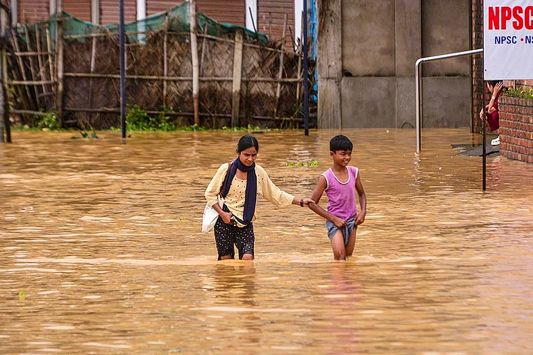
Flooding ranks among the most devastating natural disasters worldwide. It occurs when water inundates land that is typically dry, threatening lives, property, and infrastructure. Recently, India has faced unprecedented flood crises with over 3,200 deaths reported in 2024 and 1,287 fatalities from floods alone. Major states including Assam, Bihar, Uttar Pradesh, Kerala, Himachal Pradesh, Gujarat, and Maharashtra, are currently battling severe flooding and heavy rains. With over 40 million hectares of India being flood-prone and recent disasters affecting millions across northeastern and western regions, understanding flood causes, recognizing different types, and implementing robust prevention and management strategies are crucial to reducing harm.
What Causes Floods? Exploring Prevention, Preparedness, and Response
Learn how floods are triggered by extreme weather events such as heavy rainfall, cyclones, and rising river levels and how modern flood warning systems and mobile alerts play a vital role in minimizing their impact.

Types of Floods and Their Causes
Floods can be broadly categorized into riverine, coastal, flash, and urban floods.
River overflow (riverine) floods happen when sustained rainfall or snowmelt causes rivers to swell beyond their capacity, inundating adjacent floodplains.
Coastal flooding results from high tides, storm surges, or tsunamis pushing seawater onto shorelines.
Flash floods develop with little warning in steep or poorly drained terrain after intense, localized rainfall.
Urban flooding occurs when paved surfaces prevent water absorption, overwhelming drainage systems during heavy precipitation.
These phenomena are often linked to extreme weather events, such as cyclones, hurricanes, or prolonged monsoon rains, which deposit large volumes of water in short periods.
Flood Risk Assessment and Floodplain Mapping
Effective flood risk assessment begins with detailed floodplain mapping. By using topographic surveys and hydrological models, authorities can identify areas prone to inundation during various scenarios, such as a 10-year or 100-year flood event. Governments and disaster agencies often publish these maps online. For instance, on June 16, 2025, the Union Home Minister launched the Flood Hazard Zonation Atlas of Assam, delivering near-real-time flood risk visuals, comparable to FEMA’s NFHL, and greatly enhancing flood preparedness and response in the region.
Flood Prevention and Flood Barriers
Preventing floods involves both structural and non-structural measures:
Structural measures include levees, dams, retention basins, and flood barriers (e.g., movable gates along rivers or tidal walls). The Netherlands’ Delta Works is a world-renowned example of engineering designed to keep storm surges at bay.
Non-structural measures focus on land-use planning, zoning laws that discourage development on floodplains, and market-based instruments like flood insurance.
Combining flood barriers with greening strategies, such as restoring wetlands, can yield natural buffers that slow water flow and absorb excess runoff.
Flood Warning Systems
An effective flood warning system integrates real-time monitoring of rainfall, river levels, and tide gauges with rapid communication channels. Meteorological departments issue alerts, often color-coded as “watch” or “warning”, to inform communities and emergency responders. The Indian Meteorological Department’s mobile app and the European Flood Awareness System (EFAS) exemplify platforms that provide timely forecasts and hazard maps.
Preparedness and Community Engagement
Preparedness hinges on community awareness and training. Local governments and NGOs conduct drills that teach residents how to evacuate, secure utilities, and assemble emergency kits. Schools and workplaces incorporate disaster response strategies into safety protocols, ensuring everyone knows shelter locations and emergency contacts.
Response: Staying safe during and right after floods
During the event
Heed official instructions immediately. Do not wait to confirm with neighbors or social media.
Avoid floodwaters. Six inches of fast water can knock you down; two feet can sweep a car away. Floodwater may conceal open drains, debris, or live wires.
Turn around, don’t drive through. Choose alternate routes or delay travel until waters recede.
Power and gas safety: If instructed and safe to access, switch off mains. Never touch electrical equipment in standing water.
Shelter wisely: Move to higher floors if evacuation isn’t possible; avoid sealed basements without ventilation.
Immediate post-flood actions
Health first: Treat water as contaminated; boil or use purification methods. Wear gloves and boots when cleaning.
Document damages: Photos and lists help with insurance and relief claims.
Dry out quickly: Ventilate, remove wet materials, and disinfect to prevent mold and disease.
Beware of structural risks: Cracks, warped doors, or sagging ceilings warrant professional inspection before reoccupation.
Coordinated recovery
Transparent relief distribution: Publish beneficiary lists and criteria to build trust.
Resilient reconstruction: Elevate utilities, use flood-resistant materials, and redesign street profiles to channel water safely.
Mental health support: Floods are traumatic; offer counseling alongside material aid.
Integrating Technology and Policy
Modern flood management increasingly relies on technology:
Satellite data to monitor precipitation patterns.
Internet of Things (IoT) sensors for real-time water level tracking.
Machine learning models for improving forecast accuracy and lead times.
Governments integrate these tools into policy frameworks, updating building codes, incentivizing green infrastructure, and boosting funding for research on extreme weather events.
Quick checklist
Before the season
Check your home’s flood risk and insurance coverage.
Clear rooftop and yard drains; report clogged public drains.
Prepare a 72-hour emergency kit and waterproof a document folder.
Save emergency numbers; join your local alert channel.
When a warning is issued
Move vehicles and valuables to higher ground.
Charge phones and power banks; fill water containers.
Follow official routes; assist neighbors who may need help.
After waters recede
Use treated/boiled water; discard food exposed to floodwater.
Photograph damage before cleanup; file claims promptly.
Disinfect living areas; dry thoroughly to prevent mold.
Flood risk stems from how water interacts with our built environment. India now combines floodplain zoning and embankments with AI-driven forecasting and community-led response forces. With advance warnings, real-time satellite monitoring, and coordinated multi-agency action, prevention lowers impacts, preparedness buys critical time, and swift response saves lives, transforming floods from devastating surprises into predictable, manageable events.

