Two glacier-linked disasters struck the high Himalayas—one in June 2005 in Himachal Pradesh’s high-altitude tribal district of Kinnaur, along the frontier with China-occupied Tibet; the other in early 2021 in the upper reaches of Uttarakhand’s Chamoli district. Though separated by hundreds of kilometres, the two shared striking similarities—a fragile mountain terrain, retreating glaciers, rapidly warming climate and extremely destructive ice-avalanches in the Himalayas’ most vulnerable spots.
InDepth | From Nepal to Ladakh: Why the Himalayas Need a Cross-Border Early Warning System
For the states in the fragile Himalayan region, real-time monitoring and coordination across borders are critical

The Chamoli floods, triggered by a glacier collapse from the slope of Ronti peak, left over 200 people dead. Many also went missing or were trapped inside the tunnels of hydro-power projects due to the flash floods raging in the Rishiganga and Dhauliganga rivers. There were no heavy rainfall warnings or weather alerts prior to the floods. The Sutlej floods of 2005, caused by the bursting of the glacier-fed Pareechu Lake in the Chinese territory of Tibet, inflicted widespread destruction on Himachal Pradesh but there was no loss of life. The floods wrecked roads, bridges, power projects and villages along the banks of the Sutlej. But early warnings had enabled timely evacuations, making a critical difference.
Retired India Meteorological Department meteorologist Anand Sharma says, “In a fragile, transboundary mountain region like the Himalayas, real-time monitoring and coordination across borders are critical to reduce the impact of disasters.” Pointing out that mountains are inherently prone to disasters and these have been happening for decades, he says that the real question is “how to minimise their impact while respecting the integrity of the ecosystem, not ignoring the warning signs”.
Frequent and Destructive Disasters
The recent flood in Nepal is yet another loud warning signal that the Himalayan region is suffering from the effects of extreme climate change and intense human activity. Across Uttarakhand, Himachal Pradesh, Jammu & Kashmir, Sikkim and Ladakh, cloudbursts, flash floods, glacier lake outburst floods (GLOFs), ice-avalanches and landslides have become more frequent and destructive.
Himachal Pradesh Chief Minister Sukhvinder Singh Sukhu says that the frequency of such disasters in the Himalayan region are “clear evidence of climate change”. He has requested Union Home Minister Amit Shah for a comprehensive scientific study on changing weather, rising temperatures, cloudbursts, landslides and GOLFs and for framing a policy to tackle the problem. Himachal Pradesh had faced the worst-ever flash floods, torrential rains, landslides and cloudbursts in 2023 and 2025, leaving 900 people dead and casuing a loss of around Rs 16,000 crore.
“Last month, the Central government set up a multi-sectoral central team to scientifically study the reasons for increasing frequency and intensity of cloudbursts, flash floods, landslides and extreme rainfall in the Himalayan states,” Union Health Minister J.P. Nadda, who hails from Himachal Pradesh, told Outlook.
Advertisement
In the wake of the floods in Nepal, Union Home Secretary Govind Mohan chaired a meeting in Delhi on September 3, 2026, to review the preparedness of Himalayan states and Union Territories (UTs) against the risks of GLOFs and snow avalanches. The states and UTs presented their respective strategies for preparedness and mitigation and were advised to maintain close coordination among state agencies, district administrations and scientific and technical institutions so that early warnings could be acted upon promptly.
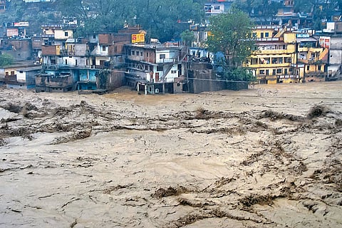
A Vulnerable Spot: A glimpse of the flooded Mandakini River in Chamoli district, Uttarakhand | Photo: PTI
Dealing with Growing Concerns
The growing concerns in the Himalayan states are glacier retreat, cloudbursts and ice-avalanches. In March, 2026, Kathmandu-based International Centre for Integrated Mountain Development reported that glaciers across the Himalayas are losing ice at twice the rate observed since 2000. Between 1990 and 2020, the region’s glaciers lost approximately 12 per cent of their total area and nine per cent of their estimated ice reserves. It also warned that the region could lose about one-third of its glacier volume by the end of the century. The meltwater holds potential to contribute to the growth of glacial lakes.
Advertisement
“These lakes may be held back by fragile moraine dams. If an avalanche, landslide or sudden surge of water breaches the natural dam, the flash flood can easily race downstream with enormous destructive power,” says Surjit Singh Randhawa, a former principal scientist at HP Council for Science, Technology and Environment and an expert on glacier studies.
Last week, the Indian Institute of Technology Mandi released a study of around 2,000 glacial lakes in Himachal Pradesh. The report notes that glacier lakes have expanded by 28.45 per cent from 2015 to 2025; nine lakes are classified as ‘very high risk’ and five as ‘high risk’. Increased tourism activities, pollution and dust deposits on glaciers can accelerate melting while permafrost loss may destabilise the terrain, the report warns.
The National Disaster Management Authority has identified four glacier lakes requiring immediate attention: Ghepan, Vasuki, Kashang and a lake near Baspa. Researchers found that glacial lakes in Himachal Pradesh have expanded by 30 to 60 per cent over the past decade. The State Disaster Management Authority (SDMA) has stepped up its monitoring of 67 vulnerable glacier lakes, most of which are located in the high mountains of Kinnaur and Lahaul-Spiti. The rapidly expanding Ghepan Lake in Lahaul-Spiti district poses a major GLOF risk to 34 downstream settlements, including Sissu village, a tourist hotspot across the Rohtang tunnel.
Advertisement
Pushpinder Rana, special secretary, SDMA, says,“The government is preparing to set up an early-warning system for four of the most vulnerable lakes in Kinnaur and Lahaul-Spiti. These are being monitored through satellite-based observations and other available data.”
In Sikkim, where 400 glacier lakes have been identified, 16 sensors have been installed to continuously monitor the threat of GLOFs. In October 2023, one of the most devastating GLOFs in Sikkim’s history struck South Lhonak Lake after a massive chunk of rock, ice and unstable glacial moraine collapsed into it. Scientists called it a “Himalayan tsunami”.
In Ladakh, studies have found a significant rise in glacier snowline altitude. The Suru and Zanskar basins have shown changes. The snowline has risen beyond the maximum elevation of some glaciers’ accumulation zones, leaving a few glaciers with no sustainable accumulation area. The Union Territory had faced devastating flash floods in August 2010. It also experienced flooding in 1993, 2006, 2015, 2023 and 2026.
Advertisement
A senior scientist at the University of Kashmir, Srinagar, says that rising temperature and human-induced factors in Kashmir have resulted in glaciers’ retreat, leading to the formation and expansion of glacier lakes. Gangabal and Nundkol have been identified as highly susceptible to GLOFs. The government has formed a focused glacier lake outburst flood monitoring committee to prepare a plan to coordinate, monitor and mitigate the impact of glacier lake-related disasters. Fourteen high-risk and three moderate-risk glacier lakes have been identified for focused monitoring and mitigation.
Uttarakhand, a mountain state prone to frequent disasters, was devastated by the 2013 Kedarnath flash floods triggered by excessive rainfall. Around 5,000 to 6,000 people lost their lives and several went missing. P.S. Negi, a former scientist at the Wadia Institute of Himalayan Geology, attributes the floods primarily to climate change but more specifically, his study showed it as “a rare convergence of the southwest monsoon and westerly disturbances, causing a massive cloudburst and relentless heavy rain, further compounded by the breach of Chorabari Lake, unleashing a devastating torrent of water.”
After Nepal’s catastrophic floods, Uttarakhand Chief Minister Pushkar Singh Dhami has ordered scientists and the state administration to step up regular monitoring of 13 sensitive glacier lakes in the state, particularly Saraswati Tal and Kedartal in Chamoli and Uttarkashi, respectively. The authorities plan to use remote sensing, drones and sensor-based technology to detect potential hazards and improve early-warning systems for downstream areas.
Planned Growth is Crucial
Negi says that unchecked construction, deforestation and haphazard hydroelectric projects along fragile young fold mountains have severely weakened natural soil stability and constricted river channels. The Wadia Institute has been advising the government on conducting thorough, site-specific geological and geotechnical investigations before undertaking large infrastructure projects in the fragile Himalayan region.
Sharma points out that early-warning systems alone can’t offer a solution. The Himalayas are severely prone to cascading and multi-hazard disasters. This is not simply because of climate change but also about how we build and develop in the fragile mountain terrain.
“All infrastructure and economic growth activities must be planned around the fragility and carrying capacity of the mountain ecosystem,” Sharma says. “Development should not itself become a trigger for disasters. Though every single disaster is a lesson, there is social amnesia in forgetting things.”
Ashwani Sharma is a journalist based out of Shimla
Published At: