
“Sir, there is a very large lake called Kanasar, which I came across while herding my sheep years ago,” said Surendra, a shepherd and part-time trekking guide who has travelled with me on a few treks in the Western Garhwal region. I promptly checked all the resource material I had for the region and drew a blank, and knew that I’d have to go see this lake for myself. On June 13 this year, when our group gathered on a high ridge overlooking Kanasar lake (at 4,400m), we were unprepared for just how large it really was. Even in June, most of the lake — surrounded by steep snow-covered slopes — had a thin ice blanket. But then again, the time of year doesn’t matter here; on the banks of Kanasar, time stands still.
Days 1-3
We started our trek at Sangla (2,700m) in Kinnaur. Typically, treks begin around the 2,000m level, but starting at a higher level gave us an advantage: we bypassed the forest sections and, in a matter of hours, were walking through beautiful meadow stretches. Also, the Kinnaur side has a fairly moderate gradient, which makes it easier to gain altitude. After two days of gentle walking, we were at the base of Nalgan pass (3,900m). On day three, we moved through progressively deeper snow as we got closer to the pass. Situated at a height of 4,200m, Nalgan pass gave us some excellent views of both the Kinnaur and Garhwal sides. Later in the day, we were out of the snow and comfortably settled in an inviting campsite in Nalgan valley.
Days 4-5
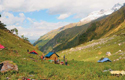
For us, the closest access route to Kanasar lake was through the Panchodar valley, which lies to one side of the Nalgan valley. The Panchodar valley is pristine, thanks no doubt to the fact that it is so seldom visited. Quite near the place our team had intended for the campsite, three bears showed up; fortunately they moved on soon, bored of our affairs. On day five, as we gained height, we passed through endless meadow stretches strewn with tiny purple and yellow flowers. We tried our best to avoid hurting the pretty young things, but that was a futile exercise — the meadows were carpeted with flowers. At the end of that day, we camped at Bijori (3,950m), which offered an almost-panoramic view of the surrounding heights.
Day 6
We began the approach to Kanasar by claiming a grass-covered ridge near the camp. The going got more complicated once we hit the snowline at 4,100m; there were long sections with knee-deep snow. Finally, we reached the top of a ridge at 4,450m; a little lower down was Lake Kanasar. I’d put the size of Kanasar at about a kilometre — enormous for a high-altitude lake. Our guide Surendra explained that the lake gets its name from its shape, the shape of an eye. And the islands in the lake, he said, look like the spots in the eye of a blind (kana) person.
Days 7-10
On the way back, we walked down the Nalgan valley, which merges with the Rupin valley and finally leads to Netwar, the roadhead. As we reached the confluence of the Panchodar and Nalgan valleys, we met shepherds coming up from Dodra Kwar, looking for pastureland. We were headed in the opposite direction, looking for a wide trail with a gradual descent. What we got instead was a faint trail overrun by boulders, which isn’t surprising, given that Nalgan is a narrow valley with steep slopes and so highly prone to landslides. Finding an appropriate campsite was a challenge on our way back, but we managed some picturesque sites between the edge of the forest and the Nalgan river. Finally, on the fourth day of our descent, we reached Netwar. And that was the end of our trek to one of the quietest corners of Garhwal.