


It is like death. We know it is coming, it is inescapable. But we do not know when, where and how. We have to live with the unpredictability of this certainty. Life is what you make of it as you wait for death, argued poet Pradip Choudhuri in his Bengali essay, Kobita Dharmo (Poetry Dharma). The case with the Himalayas is: What do we make of our knowledge that a massive disaster is impending, without having any idea of when and where?
The Himalayas, the world’s highest and youngest mountain range, spread across India, Nepal, Bhutan, China (Tibet) and Pakistan, has stood witness to many great natural calamities, especially earthquakes that devastated the region, man-made infrastructure and claimed thousands of lives. But the worst of them all is yet to come. That is what a number of scientists of global repute have been warning for over three decades. They are convinced that an earthquake above 8 on the moment magnitude scale (denoted as Mw), considered more accurate than the Richter scale in measuring large earthquakes, is impending in the Himalayas in northern India. They, however, cannot predict when and where it is going to strike.
Advertisement
Seismologist Roger Bilham, Professor Emeritus with the University of Colorado Boulder, had warned as early as in December 1994 that “the sword of Damocles is hanging over” the central Himalayan region in northern India. That month, Bilham along with scientists such as Vinod Gaur of the Bengaluru-based Centre for Mathematical Modelling and Computer Simulation, presented a set of data at a meeting of the American Geophysical Union in San Francisco elaborating their proposition.
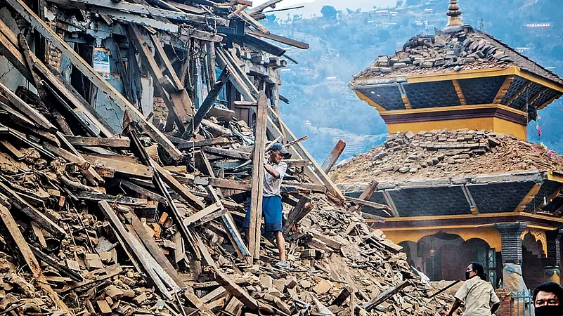
The central Himalayan region includes Uttarakhand and western Nepal. However, Uttarakhand’s population density stood at 189 per sq km in 2011, about two-and-a-half times higher than the population density of Gorkha district in central Nepal, which was the epicentre of the catastrophic 2015 Nepal earthquake.
Advertisement
Earthquakes in the Himalayas are a natural and regular occurrence. The Himalayan mountain range and the Tibetan plateau were born out of a collision between the Indian plate and the Eurasian plate about 50 million years ago. As the Indian plate continues to converge beneath the Eurasian plate, the process of mountain building continues. The stress that this process generates keeps accumulating along the plate boundaries and is released at certain intervals triggering earthquakes.
According to Bilham, it takes 30 earthquakes of 6 Mw to match the energy released by a 7 Mw earthquake and 1,000 earthquakes of 6 Mw magnitude to match the energy released by a 8 Mw earthquake. “Although many small earthquakes occur daily in the Himalayas with magnitudes of less than 4 Mw, in practice only the largest of earthquakes permit the Indian Plate to slide beneath the southern edge of the Tibetan Plateau,” Bilham wrote in a 2019 article, titled “Himalayan Earthquakes: A Review of Historical Seismicity and Early 21st Century Slip Potential”, published by Geological Society, London.
For perspective, the 2015 Nepal earthquake that claimed 9,000 lives was of 7.8 magnitude, the 2001 Bhuj earthquake that killed over 20,000 was of 7.7 magnitude and the 7.6 magnitude Kashmir earthquake in 2005 killed about 80,000 across Pakistan Occupied Kashmir (PoK), India’s Jammu & Kashmir and parts of Afghanistan. All these are ‘major’ earthquakes but not ‘great’, as the magnitude was below 8 Mw. “Distressingly, we are no closer to knowing where the next damaging earthquake will occur than two decades ago… Currently two-thirds of the Himalaya is poised to rupture in one or more great earthquakes, although we have no information of the timing of these future earthquakes,” Bilham added.
Advertisement
Predictability of Earthquakes
In 1975, China drew the attention of the world after it successfully predicted a massive earthquake near Haicheng town in northeast China and evacuated thousands of people on time. This was the first case of effective evacuation based on accurate earthquake prediction. It came as a result of a combination of methodologies—monitoring abnormal animal behaviour, which China had introduced a few years ago, and mapping foreshock sequences. Perhaps, a long sequence of foreshocks allowed Chinese scientists to predict the big one coming. This resulted in thorough investigation and documentation of China’s methods by scientists from around the world.
Advertisement
However, the same methodologies failed to predict future earthquakes. Not all earthquakes come with foreshocks.
In 2005, a group of scientists had predicted a 7.4–7.9 magnitude earthquake in the location in Nepal, where the earthquake actually hit in 2015. While the epicentre was correctly anticipated, its timing was not.
Despite all the progress that science has made in predicting disasters, earthquakes cannot be predicted. “Neither the USGS nor any other scientists have ever predicted a major earthquake. We do not know how and we do not expect to know how any time in the foreseeable future. USGS scientists can only calculate the probability that a significant earthquake will occur in a specific area within a certain number of years,” says the US Geological Survey (USGS). “It is not currently possible to predict exactly when and where an earthquake will occur, nor how large it will be. However, seismologists can estimate where earthquakes may be likely to strike by calculating probabilities and forecasts,” USGS adds.
Advertisement
One of the ways of calculating the probability is to assess if a region with stress accumulating potential has seen enough earthquakes to
release the stress to trigger a major earthquake.
The biggest Himalayan earthquakes have usually occurred along the Main Himalayan Thrust (MHT), which has been described as “one of the largest and fastest-slipping continental megathrusts on earth”. Scientists have observed that four great earthquakes have taken place along the MHT in the past 125 years: in Kangra in central Himachal Pradesh in 1905, in Nepal–north Bihar (Muzaffapur–Munger) in 1934, in Meghalaya–lower Assam in 1897 and in Arunachal–upper Assam in 1950. However, there are regions in between that have not seen any great earthquakes in centuries. When the seismicity of a region sitting along active plate boundaries reduces, it indicates the lull before a storm—building up of stress leading to future great earthquakes.
Advertisement
Well before Belham’s 1994 prophecy, late geophysicist Kailash Nath Khattri had discussed three ‘seismic gaps’ as likely locales of future great earthquakes in his 1987 article, “Great Earthquakes, Seismicity Gaps and Potential for Earthquake Disaster Along the Himalaya Plate Boundary”. Seismic gaps are sections of plate boundaries which have not ruptured in the past several decades. He identified one as the Kashmir seismic gap, lying west of Kangra, another as the central seismic gap lying between Kangra and north Bihar and the third as the Assam seismic gap roughly between the Shillong plateau in Meghalaya and the Mishmi Hills in Arunachal Pradesh.
Advertisement
The central seismic gap covers Uttarakhand and eastern Himachal, besides parts of Nepal, while the Assam gap covers most of Assam and parts of Arunachal Pradesh. All these regions fall within seismic zones 5 and 4, considered most active.
Of these gaps, the 700-km long central seismic gap, on which lies the Garhwal–Kumaon region, is considered most vulnerable to a potential great earthquake. “The central gap is very long and can rupture in three future great earthquakes,” Khattri wrote in a 1993 paper,
titled “Seismic Gaps and Likelihood of Occurrence of Larger Earthquakes in Northern India”. A few years later, in 1998, Bilham, Gaur, Frederick Blume and Rebecca Bendick wrote in a paper published in Current Science, “Great earthquakes near the northern border of India are a real threat to the people of India, a far more substantial threat than national security issues that are sometimes invoked to hinder scientific access to the region where these earthquakes nucleate.”
Advertisement
These views have been reiterated through publication of new research by scientists in the past two decades. A November 2022 paper titled “Stress Dissipation and Seismic Potential in the Central Seismic Gap of the North-West Himalaya” specifically identified Kangra and the Kumaon segments “to be potentially hazardous zones for a future great earthquake”.
Even though a major earthquake did hit the Kashmir region in 2005, it struck at a place in PoK, west of what was being estimated to be the location for the anticipated great earthquake. However, research led several experts to conclude that this was not the anticipated earthquake.
Advertisement
In a 2020 paper published in Nature, Sridevi Jade and others pointed out that the 250-km-stretch between Muzaffarabad and Kangra valley “did not record any major seismic slip” since the 7.6 earthquake of 1555 and opined that “a high magnitude earthquake is long due in this region”. This comprises large parts of Jammu and Kashmir and Ladakh regions. “Assuming the stored energy was fully released during 1555 earthquake, high geodetic strain rate since then and observed micro-seismicity point to probable future large earthquakes of Mw ~ 7.7 in Kashmir seismic gap,” the paper said.
Assam and the north Indian Himalayas are not the only regions where a great earthquake is expected. Even though the Sikkim–Darjeeling region is not in any identified seismic gap, a 2018 paper, titled “Structural Insights from Geodetic Global Positioning System Measurements in the Darjeeling–Sikkim Himalaya”, predicted, “Continued slip along the MHT, therefore, will cause a great décollement earthquake in the region.”
Advertisement
Knowledge and Action
Despite having been identified as a potential locale for great earthquakes in the future, the Himalayas lack a scientific monitoring system. Paramesh Banerjee, a seismologist, who served as the president of the Asian Seismological Commission, pointed out in a paper in 2019 that the Himalayas are “the least monitored, high risk active tectonic feature on the earth”. He wrote, “Compared to all other active and disaster prone tectonically active regions of the earth like Japan, Western coast of USA, Indonesian islands and Western coast of South America, the Himalayan range has (the) least number of GPS monitoring networks, seismic network, gravity measurements, SAR or LIDAR coverage.”
Advertisement
One of the major concerns is the mushrooming of buildings, violating regulations, and the construction of mega hydropower projects. Unregulated construction has transformed hill stations like Darjeeling and Shimla into concrete jungles. “Constructing buildings violating the stipulated height and on slopes beyond permissible level have become a major concern in the urban localities of Darjeeling. It could result in catastrophic effects if a major earthquake strikes the region,” says Ritesh Portel, former chairman of the Darjeeling Municipality.
Advertisement
Concerns around mega hydropower projects that have been built in this region have prevailed since the 1990s, as scientists kept warning against such projects in the region. Despite that, Himachal is India’s current hub of hydel projects, Uttarakhand is another major one and Arunachal Pradesh is designated as ‘India’s future powerhouse’.
Speaking to Outlook, geologist Yash Pal Sundriyal of Hemwati Nandan Bahuguna Garhwal University opines that the stress accumulated beneath the surface of earth can be released if a 7.5 or 8 magnitude earthquake takes place in about 100 years. However, Uttarakhand has witnessed only two 6.5 magnitude earthquakes, the one in Chamoli in 1991 and the other in Uttarkashi in 1999, after the 7.5 magnitude earthquake in Almora in 1803. “Geologists and geophysicists consider Uttarakhand to be part of the central seismic gap and are afraid that a great earthquake is going to strike Uttarakhand. If an earthquake of such magnitude breaches the large dams, it is going to make things much worse,” he says.
Advertisement
While government authorities have always defended these projects, saying the construction was designed to withstand impacts of earthquakes of such magnitude, scientists have remained skeptical. According to Sundriyal, minor earthquakes have their impacts on the stability of the region. “We cannot feel earthquakes of the magnitude of 2.5 or 3, but they are being generated continuously along fault lines like the MCT and MBT. We can feel earthquakes only when they are above 3.5 in magnitude. But this continuous process of generating earthquake waves makes materials weaker and more unstable,” he says, while elaborating on the risks of heavy construction projects in their region.
Advertisement
The impact of climate change—glacial melt and heavy rain in quick spells, in particular—have only worsened the disaster probability of the Himalayas, especially by glacial lake outburst floods and flash floods. Though Sikkim is expected to be at a lesser risk from great earthquakes than northern India or Kashmir, the state faces the highest threat from glacial lake outburst floods.
Several scientists have said in the past that keeping these factors in mind is an absolute necessity while planning development in the Himalayas. In a contorted view, however, a number of studies have pointed out that the indigenous earthquake-resistant constructions in these regions are paving the way for modern architectural designs.


