In November, the death of six people in police action along the Assam-Meghalaya border brought renewed focus to the century-old internal border disputes that the Northeastern states are facing with each other. While talks on border dispute are on with most of the states, the complexity of arriving at a political solution lies in the fact that the seeds such disputes were sowed in the colonial era. Apart from Meghalaya, Assam has ongoing border conflicts with Arunachal Pradesh, Nagaland and Mizoram—neighbouring states once part of undivided Assam.
The history of Northeast India till India’s independence is a history of expansion and alienation by the British for administrative ease and resource extraction. Post-independence, it became a process of national integration by state formation based on the demarcations laid down during the British Raj. In this period, especially post the 1962 Indo-China war, any ethnic movement was considered as against national integrity, while totally ignoring the haphazard boundary lines drawn by the British that dismissed the way communities used to traditionally live during the pre-British era.
Advertisement
Creation and Recreation of Boundaries
Awa mei ri pat re tuna kai-su saam-su mak rio.
(Don’t stop building houses and granaries because the Awa/Burma war has come.)
—A Naga proverb
In the early part of the 13th century, the Shans from Upper Burma established the Ahom kingdom in the Brahmaputra valley. Towards the 17th century, however, repeated invasions by Burmese army from present-day Myanmar, weakened the six-century-old kingdom that had successfully resisted the Mughals. The first expedition of the Ahom Kingdom took place when Ahom king Gaurinath Singha sought assistance from the British to save the kingdom from repeated Burmese attacks. Little did he realise that this move would go on to decide the history of state formation in the Northeastern region.
Responding to the king, Governor-General Lord Cornwallis, in the first expedition, in 1792, sent a team of British officials under Captain Welsh. The British emerged victorious in the First Anglo-Burmese war (1824-26). In 1826, through the Treaty of Yandabo, Welsh acquired complete control over Assam, Manipur, Cachar, and Jaintia, as well as Arakan province and Tenasserim in modern-day Myanmar. “Although few Englishmen ever heard the name of Captain Welsh, his memory still held in reverence by such of the Assamese as have retained the tradition of his expedition, and it is probable that the remembrance of his mild and just rule (for he virtually governed the country for 18 months) made the Assamese the more readily accept us as true friends, when we annexed the province 31 years after he left it,” wrote Lieutenant Colonel J. Johnstone, Political Agent, Manipur, in his book Captain Welsh’s expedition to Assam in 1792, 1793 and 1794.
However, the complex geography, multi-ethnicity and vivid culture posed a significant challenge for the British to draw a solid boundary of the region that they wanted to take over from the Ahom kingdom.
Notably, the Treaty of Yandabo mentioned just four ‘valley kingdoms’—Assam, Manipur, Cachar and Jaintia. It left out the tribal communities affected by the Burmese occupation. To maintain peace between the hills and the plains, and avert raids of hill tribes in plain villages, Ahom kings followed an appeasement policy. The Nagas, who often came down from the Naga Hills, were granted revenue free land called ‘khat’ and fishing waters called ‘bheel’ in the plains. The Adis from Arunachal Hills were granted rights over the fish and gold in Dihong river, an upstream tributary of Brahmaputra. Likewise, the Bhutias, Akas, Nyishis and Miris tribes were granted ‘posa’, a kind of annual revenue payment from villages in the plains.
The British Raj, however, were ignorant about the region’s political texture, and diluted these systems after 1826. Deprived of their resources, the hill people organied frequent raids. The British officials posted in the region responded to these raids with retaliatory measures. They established outposts, sent expeditions and even interfered in internal disputes of the tribal societies. The hill tribes, oblivious to the newly drawn boundaries and the physical limits that it set up, tried to protect their lands, territories and resources by raiding the plains. The mere existence of the tribes, based on their land and territory and the complex tapestry of their language and culture, were neglected by the British while they demarcated their territory and set down the physical limits of their administration.
According to Dhiren A. Sadokpam, an Imphal based independent researcher and journalist, “Post the Burmese invasion and the Treaty of Yandaboo, the contours of border issues took a new turn. In short, what I want to put across is the fact that weak rulers of the Northeast region and their inability to settle internal crisis and ward off aggressions from neighbouring kingdoms made them invite the British. Once the British entered the into this realm, the colonial approach to impose spatial demarcation denoting political geography became the norms whether or not the people inhabiting the Northeast space liked it or not. And hence, the seed of perennial conflict was sown.”
Advertisement
Policy of Annexation and alienation
The British soon started annexing hill kingdoms like the Khasi and Jaintia Hills, Garo Hills, (Meghalaya), Lushai (Mizo) Hills, Naga Hills and merged it into Assam Province despite facing fierce resistance from the communities. The Khasis led by U Tirat Sing fought fiercely against the British from 1829 and 1833. The Khasis, who inhabit the Khasi Hills of present-day Meghalaya, were brought to Assam after the Anglo-Khasi war of 1823-33. The Jaintias were brought under British control when the Jaintia Hills in Meghalaya were merged with Assam in 1835. Between the 1830s and 1860s, the hill tribes such as the Singphos, Khamtis, Nagas, Garos, etc., offered stiff resistance against British rule and inclusion into the Assam Province.
Administrative headquarters were established in the Garo Hills in 1866, the Naga Hills in 1878, and the Lushai Hills in 1895. This led to a great sense of loss for the distinctive hill communities living in independent village set-ups. Political systems like the loose confederacies of villages were not in the idea of a modern state for the British.
In his book, In The Name Of Nation, writer and academic Sanjib Baruah, says, “Certain regions of the world may have roots in deeply historical context of ethno-nationalism than others.” writes geographer Anssi Passi, are ‘ad-hoc spatial units’, put together for mundane administrative reasons or for purposes of economic planning. Northeast India belongs firmly to the latter category: regions that emerge “rapidly from the desks of planners, politicians and business coalitions, not from long historical regionalisation processes and the daily struggles of citizens.”
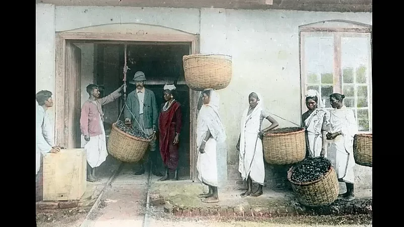
Of Tea, Inner Line and the process of alienation
In 1837, the Britishers set up its first tea garden in Chabua in Dibrugarh district in eastern part of Assam. In 1840, the Assam Tea Company began commercial production of tea on vast tracts of land in this part of the region bordering the Naga Hills.
Historian Amalendu Guha notes that by 1901, tea gardens enclosed ‘one fourth of the total settled area (amounting to five per cent of the total area) of Assam Proper (is a region in Assam that is constituted by the five colonial districts originally part of the Ahom kingdom) under their exclusive property rights. The land occupation by British tea planters disrupted the hunting and gathering economies of the Nagas, argues Sanjib Baruah.
Advertisement
To prevent hill tribes from encroaching upon the freshly carved tea gardens, the Britishers adopted an exclusion policy that led to further division of the hills and the plains. Colonial rulers in 1873 introduced an Inner Line permit under that regulates the entry of outsiders to many parts of the region, which continues till today in the four NE states. The Bengal Eastern Frontier Regulation of 1873, also empowered the British to ‘prescribe, and from time to time, alter by notification (…a line to be called the Inner Line.’). The Inner Line would supposedly give a territorial border to the region ending upon infringing lands meant for traditional livelihood of the tribals.
In his article, When was the Postcolonial? A History of Policing Impossible Lines Bodhisattva Kar argues that the Line was ‘in fact a revisable, mobile, and pliant boundary’ and shows how ‘well until the second decade of the twentieth century, the Line was repeatedly redrawn in order to variously accommodate the expansive compulsions of plantation capital, the recognition of imperfection in survey maps, the security anxiety of the state, and the adaptive practices of internally differentiated local communities.’”
According to Kar, the British frequently redrew the Inner Line based on their need to expand tea plantations or discovery of natural resources like coal beyond the Line.
Advertisement
In another policy of alienation, the Britishers under the government of India Act 1935, divided the hill areas as Excluded and Partially Excluded Areas. The Excluded Areas, including the Naga and Lushai Hills districts, were placed under the executive control of the Assam governor. British subjects were restricted from accessing this area through the introduction of the Inner Line Regulation. Thus these areas remained outside the process of development. After Independence, these areas demanded autonomy. For instance, Nagaland has witnessed one of the longest insurgency of India because of the demand for a Greater Nagalim carved out of Naga inhabited areas such as Assam, Arunachal Pradesh, Manipur and parts of Myanmar, territories upon which they lay claim as their own in the pre-British era.
Advertisement
The seven confused sisters
Right after Independence, tribes in the Hills of Northeast India started demanding regional autonomy, citing the way they were included in the Undivided Assam through policies of annexation and expansion. Following such demands, the Interim government of India introduced the Sixth Schedule in the Constitution that provided for councils at regional and district level to administer the erstwhile ‘Excluded Areas.’ Post-Independence, Nagaland was the first state in Northeast India to achieve statehood in 1963 out of Assam. Mizoram, Arunachal Pradesh, and Meghalaya followed suit. However, many political groups started opposing Assam’s border lines, citing pre-British documents of having claims in territories now falling in Assam.
For instance, the boundary dispute between Assam and Mizoram in 2021 took a violent turn when the police of both states engaged in a gun war. The root of the conflict can be traced to the demarcation of Lushai Hills from the Cachar plains by the British in 1875. Lushai Hills and adjoining regions were administered by Cachar district administration till the end of colonial rule. Mizoram became a Union territory in 1972, and then a state in 1987. The Mizos claim that they abide by the 1875 demarcation, brought into effect by the British to completely sequester the movements of the Lushai tribes.
In the case of Arunachal Pradesh, the erstwhile Northeast Frontier Agency (NEFA) administered by New Delhi, the root cause of border conflict with Assam lies in the 'Inner line'. After Independence, the Assam government assumed administrative jurisdiction over the area that became an independent state in 1987. However, a 1951 report by the then Assam chief minister Gopinath Bordoloi became the bone of contention. The report stated that 3,648 sq km area was transferred to Assam from Arunachal Pradesh (erstwhile NEFA), and not in consultation with the state’s tribal organisations.
Meghalaya and Assam differ at 12 stretches of the 884 km boundary. The border talks between Assam and Meghalaya had resulted in an amicable solution on certain points, but the recent clash in Murkoh village has produced uncertainty for such talks in future.
“In the so called post-colonial era, the tradition of colonial politics lingered on. Even if those who took over ushered and steered the country in a democratic order, their approach was hindered by either total ignorance of the political territories or a state of dormancy caused by years of indifference to the issues.” adds Dhiren A. Sadokpam.